Within Triangulation
How far apart should sky stations be?
The spacing between observing stations decides whether triangulation gives a tight location or another vague guess.
On this page
- Short baselines for nearby drones
- Long baselines for aircraft and meteors
- Why shallow crossing angles create uncertainty
Page outline Jump by section
Introduction
The distance between observing stations—known as the baseline—is one of the most important design choices in an automated UAP detector network. Two perfectly calibrated cameras can still produce poor distance estimates if they are placed too close together for the objects they are observing, while stations that are too far apart may struggle to observe the same target at all. The aim is not simply to maximise separation, but to match the baseline to the expected range of the object so that the viewing directions intersect at a useful angle. This geometric trade-off determines whether triangulation produces a tightly constrained three-dimensional position or merely another uncertain estimate. The same principles underpin professional surveying, stereo vision, meteor tracking and astronomical parallax measurements, and they apply equally to automated UAP observation systems. [conference.sdo.esoc.esa.int]conference.sdo.esoc.esa.intTriangulation of Space-based Optical Measurements for…While this methodology is well assessed in the literature for ground-based senso…

Why baseline length matters
Triangulation works by intersecting two lines of sight from known locations. If the observing stations are very close together relative to the object’s distance, each camera sees almost the same direction. The resulting parallax—the apparent shift of the object against the background—is extremely small, making the estimated range highly sensitive to even tiny pointing errors.
Conversely, increasing the baseline increases the measurable parallax, making distance estimates more stable. However, this benefit does not continue indefinitely. As stations become widely separated, they are more likely to have different viewing conditions, different horizon limits, different weather, or simply fail to observe the same object at the same time. Wide baselines also make matching the same target between stations more difficult because each camera views the object from a noticeably different perspective. These competing effects are well known in stereo vision and optical tracking systems, where baseline selection is treated as a fundamental design parameter rather than an afterthought. [arXiv+2arXiv]arxiv.orgarXiv Baseline and Triangulation Geometry in a Standard Plenoptic CameraBaseline and Triangulation Geometry in a Standard Plenoptic CameraOctober 9, 2020…
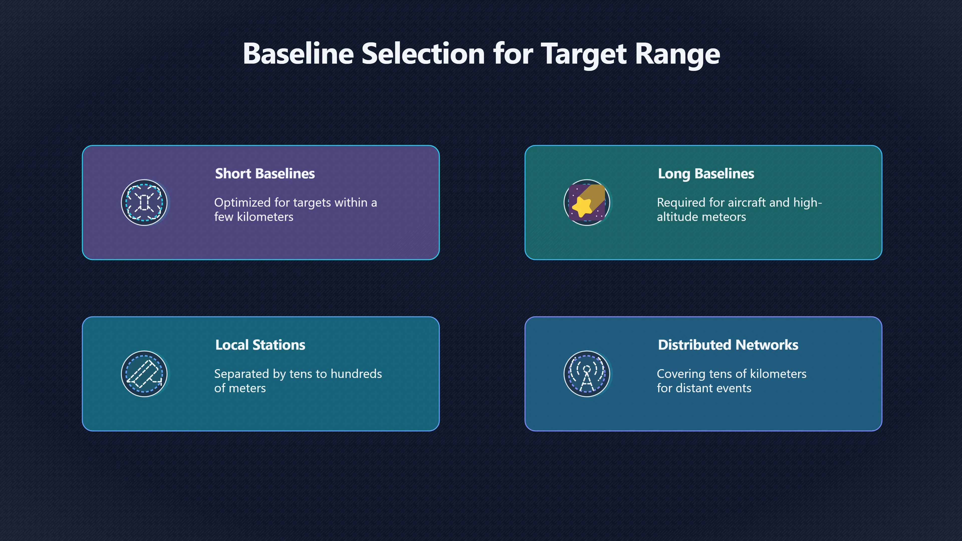
Short baselines for nearby drones
Short baselines are best suited to nearby targets, particularly those expected within a few hundred metres to a few kilometres.
Examples include:
- consumer drones
- birds
- balloons
- local aircraft during approach or departure
- insects or debris that might otherwise produce false UAP reports
With nearby objects, even a modest station separation produces measurable parallax. Stations separated by tens or hundreds of metres can often estimate altitude and distance accurately enough to distinguish a low-flying drone from a distant aircraft. A much larger baseline provides relatively little extra benefit for these ranges while increasing the risk that buildings, trees or terrain block one observer’s view.
This is one reason why many robotic stereo vision systems designed for autonomous vehicles and drones use comparatively short baselines: the expected operating range is limited, and excessive separation reduces the chance that both cameras maintain overlapping fields of view. [arXiv]arxiv.orgarXiv Morph Eyes: Variable Baseline Stereo For Quadrotor NavigationarXiv Morph Eyes: Variable Baseline Stereo For Quadrotor Navigation
Long baselines for aircraft and meteors
Objects many kilometres away require significantly larger baselines before useful parallax becomes measurable.
For aircraft cruising tens of kilometres away, a baseline of only a few metres produces almost identical viewing directions. Even slight calibration errors can overwhelm the genuine geometric difference. Increasing station separation to hundreds of metres or several kilometres improves range estimation because each observer sees the object from a meaningfully different direction.
Meteor observation networks demonstrate this principle in practice. Their cameras are intentionally distributed over large areas so that bright meteors high in the atmosphere can be reconstructed in three dimensions. Networks are designed so that multiple stations have overlapping sky coverage while maintaining enough separation to generate useful parallax for objects roughly 80–120 km above Earth. Similar reasoning applies when designing UAP detector networks intended to estimate the altitude of distant aircraft, re-entering space debris or unusually bright atmospheric events. [Bartol Research Institute]bartol.udel.eduBartol Research InstitutePHYS133 – Lab 3 Triangulation and ParallaxThis lab consists of two parts, a practical use of triangulation on la…
Why shallow crossing angles create uncertainty
The most important geometric quantity is not simply baseline length but the intersection angle between the two sightlines.
If those lines cross at a healthy angle, small pointing errors produce relatively small position errors. If they are almost parallel, tiny measurement errors can move the estimated intersection point by many kilometres.
This explains why two carefully calibrated stations may still produce poor results for distant objects. Consider a target close to the horizon. Even if both cameras identify exactly the same object, their viewing rays may intersect at only a fraction of a degree. In that situation:
- a pointing error of only a few arcminutes can produce enormous range uncertainty
- estimated altitude becomes unstable
- calculated speed and acceleration inherit those uncertainties
- different processing methods may generate noticeably different tracks from the same observations
Professional triangulation systems therefore report uncertainty estimates rather than a single position. Modern implementations usually solve for the point of closest approach between the viewing rays instead of assuming they intersect perfectly, since measurement noise means they rarely do. [conference.sdo.esoc.esa.int]conference.sdo.esoc.esa.intTriangulation of Space-based Optical Measurements for…While this methodology is well assessed in the literature for ground-based senso…

Designing a detector network around expected targets
An automated UAP detector network should choose station spacing according to its scientific objectives rather than adopting a single “ideal” baseline.
A practical implementation often benefits from multiple scales of observation:
- Local stations separated by tens to hundreds of metres provide strong performance against nearby drones and low-altitude objects.
- Regional stations separated by hundreds of metres to several kilometres improve estimates for conventional aircraft and higher-altitude targets.
- Distributed networks covering tens of kilometres allow multiple independent measurements of exceptionally distant events such as meteors or atmospheric re-entry phenomena, provided the stations remain synchronised and have overlapping sky coverage.
Some proposed multi-sensor observatories therefore emphasise network geometry alongside camera calibration, timing accuracy and sensor synchronisation. The baseline is treated as part of the measurement instrument rather than simply the distance between two cameras. [conference.sdo.esoc.esa.int]conference.sdo.esoc.esa.intTriangulation of Space-based Optical Measurements for…While this methodology is well assessed in the literature for ground-based senso…
Practical trade-offs beyond geometry
Baseline selection also affects operational reliability.
Longer separations increase dependence on accurate time synchronisation because rapidly moving objects occupy noticeably different positions between even small timing offsets. They also require more sophisticated software to associate the same object across multiple stations, particularly in busy skies containing aircraft, satellites and birds.
Environmental conditions become increasingly important as well. Stations separated by several kilometres may experience different cloud cover, haze or lighting, reducing the number of events visible simultaneously. A theoretically optimal geometric baseline can therefore perform poorly if common visibility is infrequent.
For these reasons, many successful observational networks prioritise planned geometry with overlapping coverage rather than simply deploying the maximum possible number of randomly placed cameras. A smaller network with carefully chosen baselines often produces more reliable distance estimates than a larger network whose stations were positioned without regard to triangulation geometry. [conference.sdo.esoc.esa.int]conference.sdo.esoc.esa.intTriangulation of Space-based Optical Measurements for…While this methodology is well assessed in the literature for ground-based senso…

Amazon book picks
Further Reading
Books and field guides related to How far apart should sky stations be?. Use these as the next step if you want deeper reading beyond the article.
Astronomical image and data analysis
First published 2002. Subjects: Data processing, Imaging systems in astronomy, Imaging systems, Astronomy, data processing, Physics.
Handbook of CCD astronomy
First published 2006. Subjects: Charge coupled devices, Technique, Astronomy.
Practical Astronomy with Your Calculator Or Spreadsheet
Explains triangulation and positional calculations.
Endnotes
-
Source: conference.sdo.esoc.esa.int
Link: https://conference.sdo.esoc.esa.int/proceedings/sdc9/paper/335Source snippet
Triangulation of Space-based Optical Measurements for...While this methodology is well assessed in the literature for ground-based senso...
-
Source: arxiv.org
Title: arXiv Baseline and Triangulation Geometry in a Standard Plenoptic Camera
Link: https://arxiv.org/abs/2010.04638Source snippet
Baseline and Triangulation Geometry in a Standard Plenoptic CameraOctober 9, 2020...
Published: October 9, 2020
-
Source: arxiv.org
Title: arXiv Morph Eyes: Variable Baseline Stereo For Quadrotor Navigation
Link: https://arxiv.org/abs/2011.03077 -
Source: arxiv.org
Link: https://arxiv.org/abs/1906.01193 -
Source: arxiv.org
Link: https://arxiv.org/pdf/2306.04516Source snippet
Scientific Perspectivesby R Dodson · 2023 · Cited by 3 — This development would bring order of magnitude improvements of sensitivity and...
-
Source: bartol.udel.edu
Link: https://www.bartol.udel.edu/~owocki/phys133/3%20-%20Triangulation%20and%20Parallax.pdfSource snippet
Bartol Research InstitutePHYS133 – Lab 3 Triangulation and ParallaxThis lab consists of two parts, a practical use of triangulation on la...
-
Source: Wikipedia
Link: https://en.wikipedia.org/wiki/Triangulation
Additional References
-
Source: ccatobservatory.org
Link: https://www.ccatobservatory.org/papers/ -
Source: youtube.com
Link: https://www.youtube.com/watch?v=op_wCAep23oSource snippet
Governments Using AI To Decode Massive UFO Databases | WION Podcast...
-
Source: youtube.com
Title: Inventor says his new [radar]({{ ‘radar/’ | relative_url }}) network could spot UAPs | Reality Check
Link: https://www.youtube.com/watch?v=mwsEatnZ358Source snippet
SOMETHING IS HAPPENING — We Are Detecting Anomalous Objects | What They Don't Explain...
-
Source: youtube.com
Title: More “Reality Check” episodes
Link: https://www.youtube.com/watch?v=rEYDY2EMm8cSource snippet
"Retired U.S. Navy Rear Admiral Tim Gallaudet on Grusch, UAP claims: Full Interview | Reality Check: [https://www.youtube.com/watch?v=Qh_h5..."](https://www.youtube.com/watch?v=Qh_h5...")...
-
Source: youtube.com
Title: How Military Sensors Proved UFO Craft Were Physically Real | WION Podcast
Link: https://www.youtube.com/watch?v=H6eK1VbrHPYSource snippet
Inventor says his new radar network could spot UAPs | Reality Check...
-
Source: youtube.com
Title: Triangulation and Trilateration
Link: https://www.youtube.com/watch?v=TQkMRZa2blUSource snippet
Triangulation vs Trilateration explains how geometric baselines and viewing angles affect positioning accuracy...
-
Source: ui.adsabs.harvard.edu
Link: https://ui.adsabs.harvard.edu/abs/2025jwst.prop.8007T/abstractSource snippet
A Tielens · 2025 — JavaScript is disabled. In order to continue, we need to verify that you're not a robot. This requires JavaScript. Ena...
-
Source: youtube.com
Link: https://www.youtube.com/watch?v=Saw1Eg2iZaISource snippet
rom fizzics.org...
-
Source: youtube.com
Link: https://www.youtube.com/watch?v=Stm3GywKspwSource snippet
24 - Triangulation and ParallaxIs this one connected curve, or two? Bet you can't explain why... Morphocular · 560K views; Where...
-
Source: youtube.com
Link: https://www.youtube.com/watch?v=Qh_h5OUMKIE
Topic Tree