Within NASA Gap
The Weather Around a UAP Sighting Matters
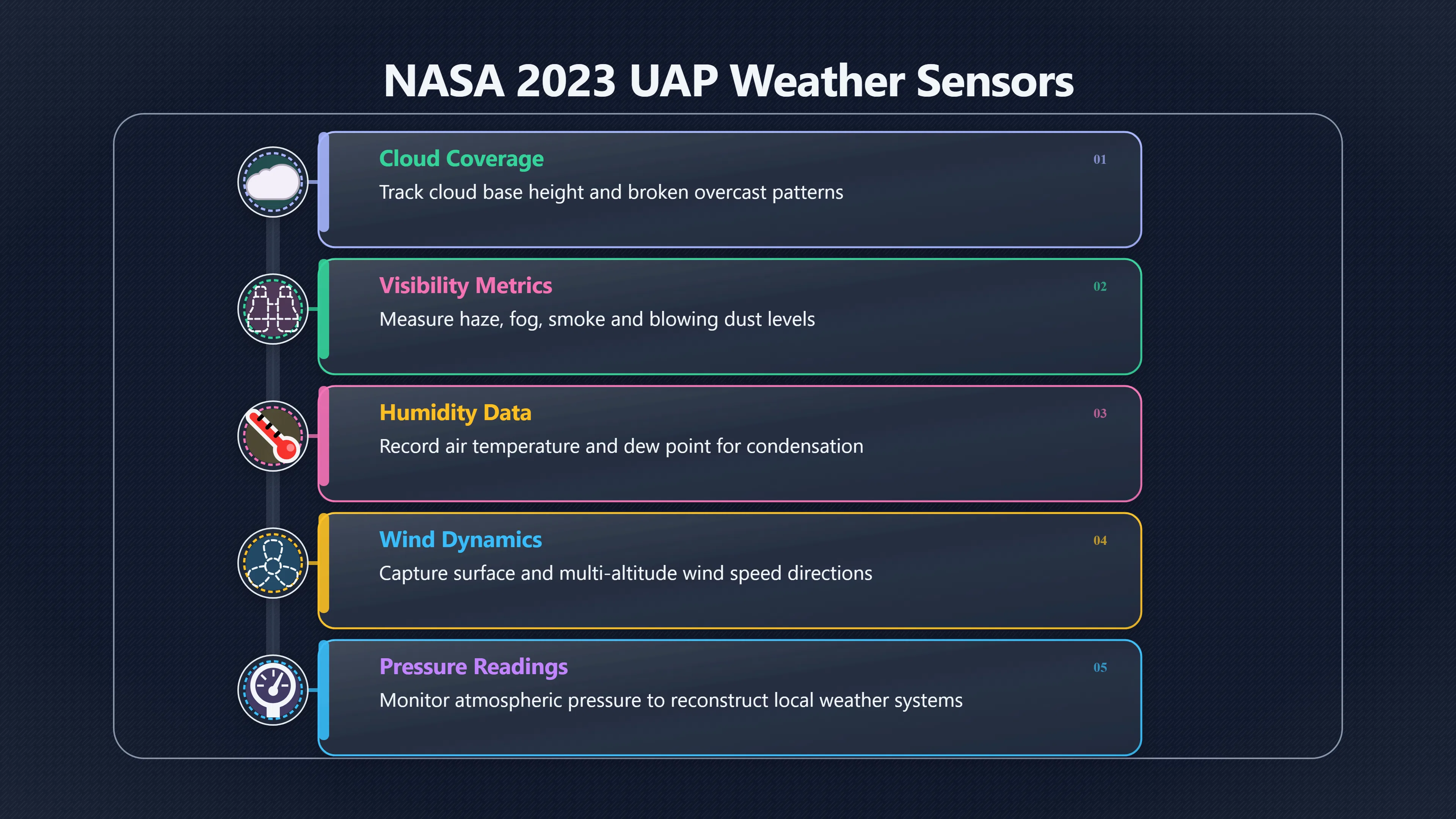
Cloud, humidity, wind, visibility and temperature records help separate unusual objects from atmospheric effects and sensor confusion.
On this page
- Which weather fields belong in a detection record
- How atmosphere changes optical and infrared signatures
- Where local weather sensors can reduce false alerts
Page outline Jump by section
Introduction
Weather is not an optional extra for an automated UAP detector. It is part of the measurement itself. The same aircraft, balloon, bird or astronomical object can appear dramatically different depending on cloud cover, humidity, wind, visibility, temperature and atmospheric stability. NASA’s 2023 Independent Study Team argued that better contextual data are essential because most existing UAP reports lack the environmental information needed to distinguish genuine anomalies from ordinary events or sensor artefacts. Recording local weather alongside every detection therefore makes a system more scientifically trustworthy by reducing false positives and helping analysts reconstruct exactly what conditions existed at the time of an observation. [NASA Science]science.nasa.govScience Independent Study Team ReportNASA ScienceIndependent Study Team ReportSeptember 13, 2023 — The study of Unidentified Anomalous Phenomena (UAP) presents a unique scien…
 Rather than treating weather as background information, an instrumented detector should treat it as another calibrated sensor. Every weather measurement narrows the range of plausible explanations and helps determine whether an unusual observation reflects something in the sky, something in the atmosphere, or a limitation of the observing system.
Which weather fields belong in a detection record
A useful detection record captures the atmosphere with almost the same care as it captures the target. Many of these measurements are already produced automatically by aviation weather stations and scientific observatories, making them practical additions to an automated UAP station. [NCEI]ncei.noaa.govday. ASOS data are archived in the Global Surface Hourly database…
The most valuable weather fields include:
- Cloud cover and cloud base height, including whether clouds were broken, overcast or rapidly changing.
- Visibility, including haze, fog, smoke or blowing dust.
- Air temperature and dew point, allowing humidity and condensation conditions to be reconstructed.
- Relative humidity, which affects infrared transmission and atmospheric scattering.
- Wind speed and direction at the surface and, where available, at multiple altitudes.
- Atmospheric pressure, useful when reconstructing local weather systems.
- Precipitation type and intensity, including rain, snow or drizzle.
- Lightning activity, which can coincide with transient luminous atmospheric phenomena.
- Solar elevation, lunar phase and illumination, because bright light sources interact differently with haze and cloud.
- Timestamped weather source, identifying whether the measurements came from an on-site weather station, a nearby aviation observation or a numerical weather model.
Recording these values continuously—not only after an alert—is especially important. Baseline conditions before and after an event often explain apparent anomalies better than the single weather snapshot taken during the detection itself.
How the atmosphere changes optical and infrared signatures
The atmosphere is an active optical system rather than an empty viewing window. Even when an object itself does not change, the air between the detector and the target can alter its apparent brightness, colour, motion and shape.
Visible-light cameras
Cloud droplets, aerosols and humidity scatter incoming light. Thin haze can enlarge bright points into glowing discs, while broken cloud can repeatedly obscure and reveal an aircraft, creating the illusion of sudden acceleration or disappearance. Temperature gradients near the ground can also produce refractive effects that distort distant objects, particularly over hot surfaces or water.
Wind contributes in more subtle ways. A balloon drifting with strong upper-level winds may appear to execute unexpected changes in direction when viewed from a moving observer, while rapidly moving cloud layers create changing visual backgrounds that complicate automated tracking.
These effects are well known in astronomy, where atmospheric turbulence limits image sharpness unless corrections are applied. Similar principles apply to any automated sky-monitoring system.

Infrared sensors
Infrared cameras introduce additional complications because they measure emitted thermal radiation rather than reflected visible light. Water vapour strongly affects infrared transmission, while rain, fog and humid air reduce contrast between targets and the background. Wind alters how quickly objects cool or warm, changing their apparent thermal signatures even when their physical properties remain unchanged. [PMC+2PMC]pmc.ncbi.nlm.nih.govThermal Infrared Sensing for Near Real-Time Data-Driven Fire…by MJ Sousa · 2020 · Cited by 89 — Thermal infrared cameras provide se…
Reflections create another challenge. Smooth or wet surfaces can reflect infrared radiation from unrelated heat sources, producing misleading thermal features if environmental conditions are ignored. Infrared imaging research consistently identifies reflections, emissivity differences and weather-dependent thermal behaviour as major causes of false interpretation. [ResearchGate+2PAS Journals]researchgate.netIn particular, atomically smooth surfaces…Read more…
For a multi-sensor UAP detector, weather measurements therefore help determine whether an apparent thermal anomaly originates from the object itself or from changing atmospheric transmission.
Local weather sensors reduce false alerts
The greatest improvement comes from measuring weather at the detector rather than relying only on regional forecasts.
Modern aviation observing systems demonstrate what is achievable. Automated Surface Observing Systems (ASOS) continuously report cloud layers, visibility, temperature, dew point, pressure, wind, precipitation and other environmental variables using calibrated sensors. These observations support aviation because pilots require an accurate description of the atmosphere at a specific location and time rather than a general forecast. The same principle benefits automated UAP monitoring. [NCEI]ncei.noaa.govday. ASOS data are archived in the Global Surface Hourly database…
A practical detector might combine:
- A compact weather station measuring temperature, humidity, pressure and wind.
- An all-sky visible camera for cloud coverage.
- An infrared sky camera capable of detecting cloud and fog during both day and night.
- Access to nearby aviation METAR observations for independent verification.
This combination allows software to reject many routine events automatically. For example:
- A bright object fading exactly as thin cloud passes across the sky becomes less suspicious.
- A thermal target weakening during rapidly increasing humidity may reflect atmospheric absorption rather than target behaviour.
- Motion matching measured wind speed becomes consistent with balloons or drifting debris.
- Poor visibility can lower confidence scores automatically instead of generating high-priority alerts.
Scientific observatories already use all-sky cameras and automated cloud monitoring to decide whether observations are reliable. Recent work has also shown that machine-learning systems can identify cloud conditions from all-sky imagery with high accuracy, making weather-aware automation increasingly practical. [arXiv+2arXiv]arxiv.orgarXiv Cloud Identification from All-sky Camera Data with Machine LearningCloud Identification from All-sky Camera Data with Machine LearningMarch 24, 2020…
Weather data improves later investigation
The immediate benefit of weather metadata is fewer false alerts, but its longer-term value is even greater.
Suppose two different stations record an unusual object. If both also preserve complete weather records, investigators can determine whether each station viewed the target through similar atmospheric conditions or whether one observation was degraded by cloud, haze or strong turbulence. This makes comparisons between independent sensors far more meaningful.
Weather records also allow analysts to reproduce historical conditions using archived meteorological data. Aviation weather archives and national observing networks routinely preserve hourly and sub-hourly observations, enabling later reconstruction of the observing environment months or even years after an event. [NCEI]ncei.noaa.govday. ASOS data are archived in the Global Surface Hourly database…
This approach matches NASA’s broader recommendation that future UAP investigations rely on complete, calibrated datasets rather than isolated images. Weather becomes part of the evidence chain rather than an afterthought. [NASA Science]science.nasa.govScience Independent Study Team ReportNASA ScienceIndependent Study Team ReportSeptember 13, 2023 — The study of Unidentified Anomalous Phenomena (UAP) presents a unique scien…
Weather should be treated as another calibrated sensor
An automated UAP detector is most credible when it records not only what appeared in the sky but also the state of the atmosphere through which it was observed. Cloud cover, humidity, wind, visibility and temperature are not merely environmental notes; they directly influence both visible and infrared measurements.
By integrating local weather observations into every detection record, automated systems can distinguish atmospheric effects from genuinely unusual observations more reliably, assign realistic confidence levels to alerts, and produce datasets that remain scientifically useful long after the original event has passed. This turns weather from a source of uncertainty into one of the strongest tools for keeping UAP detectors honest.

eBay marketplace picks
Marketplace Samples
Live-tested eBay searches with available results related to this page.


Endnotes
-
Source: science.nasa.gov
Title: Science Independent Study Team Report
Link: https://science.nasa.gov/wp-content/uploads/2023/09/uap-independent-study-team-final-report.pdfSource snippet
NASA ScienceIndependent Study Team ReportSeptember 13, 2023 — The study of Unidentified Anomalous Phenomena (UAP) presents a unique scien...
Published: September 13, 2023
-
Source: ncei.noaa.gov
Link: https://www.ncei.noaa.gov/products/land-based-station/automated-surface-weather-observing-systemsSource snippet
day. ASOS data are archived in the Global Surface Hourly database...
-
Source: weather.gov
Link: https://www.weather.gov/media/asos/aum-toc.pdf -
Source: pmc.ncbi.nlm.nih.gov
Link: https://pmc.ncbi.nlm.nih.gov/articles/PMC7730462/Source snippet
Thermal Infrared Sensing for Near Real-Time Data-Driven Fire...by MJ Sousa · 2020 · Cited by 89 — Thermal infrared cameras provide se...
-
Source: pmc.ncbi.nlm.nih.gov
Link: https://pmc.ncbi.nlm.nih.gov/articles/PMC4168422/Source snippet
The result is a false-color image...Read more...
-
Source: researchgate.net
Title: Research Gate Impacts of Atmospheric and Load Conditions on the Power
Link: https://www.researchgate.net/publication/371056313_Impacts_of_Atmospheric_and_Load_Conditions_on_the_Power_Substation_Equipment_Temperature_ModelSource snippet
Impacts of Atmospheric and Load Conditions on the Power...May 19, 2023 — Infrared thermography is a predictive maintenance tool used in...
Published: May 19, 2023
-
Source: researchgate.net
Link: https://www.researchgate.net/publication/264884438_Identification_and_Suppression_of_Thermal_Reflections_in_Infrared_Thermal_ImagingSource snippet
In particular, atomically smooth surfaces...Read more...
-
Source: arxiv.org
Title: arXiv Cloud Identification from All-sky Camera Data with Machine Learning
Link: https://arxiv.org/abs/2003.11109Source snippet
Cloud Identification from All-sky Camera Data with Machine LearningMarch 24, 2020...
Published: March 24, 2020
-
Source: arxiv.org
Link: https://arxiv.org/abs/2503.18670 -
Source: arxiv.org
Link: https://arxiv.org/html/2507.21711v1Source snippet
Nighttime Cloud Detection, Tracking and Prediction with All...29 Jul 2025 — This paper presents a novel method for real-time nighttime c...
-
Source: aqua.nasa.gov
Title: new nasa data help take whether out weather prediction
Link: https://aqua.nasa.gov/newsroom/new-nasa-data-help-take-whether-out-weather-predictionSource snippet
NASA Data Help Take "Whether" out of Weather...The new data are the most accurate, highest-resolution measurements ever taken from space...
-
Source: journals.pan.pl
Link: https://journals.pan.pl/Content/138500Source snippet
Due to the strong dependence on the fourth power...Read more...
Additional References
-
Source: ukfall.org.uk
Link: https://ukfall.org.uk/get-a-camera/Source snippet
Get your own Meteor CameraMeteor camera networks run by professional and citizen scientists are a powerful tool as we start to build a ge...
-
Source: reuniwatt.com
Link: https://reuniwatt.com/en/products-and-services/247-all-sky-observation-sky-insight/Source snippet
Sky InSight: The infrared all-sky cameraSky InSight is an infrared camera designed to observe and forecast cloud characteristics, both da...
-
Source: lup.lub.lu.se
Link: https://lup.lub.lu.se/student-papers/record/9176281/file/9176282.pdfSource snippet
detection with a thermal cameraThe solar radiation on the outdoor surface caused reflections which led to false positive readings. Shadow...
-
Source: aopa.org
Link: https://www.aopa.org/-/media/Files/AOPA/Home/News/All-News/2001/2000-Annual-Report-of-the-Aircraft-Owners-and-Pilots-Association/sa09.pdf -
Source: youtube.com
Link: https://www.youtube.com/watch?v=nuBMnluJfs0Source snippet
Replay! NASA's Release of the Unidentified Anomalous...NASA commissioned an independent study team to examine unidentified anomalous phe...
-
Source: youtube.com
Link: https://www.youtube.com/watch?v=7cEs3ntYkFMSource snippet
Unidentified Anomalous Phenomena Independent Study Report - YouTube Unidentified Anomalous Phenomena Independent Study Report - YouTube...
-
Source: avi-loeb.medium.com
Title: a new calculation on the fly to the nasa uap study 2dacaf860cac
Link: https://avi-loeb.medium.com/a-new-calculation-on-the-fly-to-the-nasa-uap-study-2dacaf860cacSource snippet
New Calculation on the Fly to the NASA UAP Study - Avi LoebThe NASA Study will examine unclassified data on UAP in an attempt to separate...
-
Source: anvil.so
Title: ultimate guide to environmental factors in thermal imaging
Link: https://anvil.so/post/ultimate-guide-to-environmental-factors-in-thermal-imagingSource snippet
19 Jan 2025 — Thermal imaging is a powerful tool for detecting temperature variations, but its accuracy depends heavily on external condi...
-
Source: linkedin.com
Link: https://www.linkedin.com/posts/%E6%89%AC-%E7%82%B9-08543231b_seeing-double-the-weird-science-of-heat-activity-7472831678038753280-GEZsSource snippet
Thermal Imaging: Emissivity is King: Shiny surfaces have low emissivity.Read more...
-
Source: facebook.com
Link: https://www.facebook.com/groups/172438633343696/posts/1650359452218266/Source snippet
yone used this and have any comments on what it's like please?...
Topic Tree