Within Sky Detectors
How Multiple Stations Pin Down a Sky Object
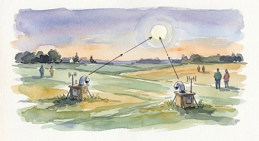
Two or more synchronized stations can turn a mysterious direction in the sky into a more testable position and path.
On this page
- Why one line of sight is not enough
- Timing and geometry between stations
- Practical barriers to synchronized networks
Page outline Jump by section
Introduction
Multi-site triangulation is the step that can turn “something was seen in that direction” into a testable estimate of where an object was, how far away it was, and how it moved. For automated instrumented UFO or UAP detectors, this is a decisive upgrade over lone-camera sightings: a single camera records an angle in the sky, but two or more synchronised stations can intersect those angles and estimate a three-dimensional path. That does not make an object extraordinary by itself. It makes ordinary explanations easier to check and extraordinary claims harder to sustain without real measurements.
This is why serious UAP data discussions keep returning to the same ingredients: calibrated sensors, accurate time, known camera positions, sensor metadata and multiple measurements. NASA’s 2023 independent UAP study stated that current analysis is hampered by poor calibration, lack of multiple measurements, missing metadata and lack of baseline data, and it described multiple well-calibrated sensors as paramount for future work. [NASA Science]science.nasa.govOpen source on nasa.gov.
Why one line of sight is not enough
A single optical station usually cannot tell whether a light is a nearby insect, a drone a few hundred metres away, an aircraft tens of kilometres away, or a satellite hundreds of kilometres up. The image gives a direction from the camera through the sky, not a distance along that line. Without range, apparent speed can be wildly misleading: a small nearby object crossing a few degrees of sky can look faster than a distant aircraft, while a distant satellite can appear steady and slow even as it moves at orbital speed.
This distance problem is central to UAP interpretation because many striking claims depend on inferred velocity, acceleration, size or manoeuvring. If the distance is guessed, the kinematics are guessed too. NASA’s report made this point in practical terms: present UAP observations are inconsistent and make it difficult to place physical constraints on events without a more rigorous, evidence-based framework. [NASA Science]science.nasa.govOpen source on nasa.gov.
Triangulation attacks that weakness directly. If Station A sees an object at one bearing and elevation, and Station B sees the same object at the same moment from a known baseline away, the two sightlines should cross or nearly cross. The geometry then yields an estimated position. Repeating that process over several frames gives a path. Once distance is constrained, analysts can compare the object’s motion with aircraft, balloons, birds, satellites, meteors, lens artefacts and weather effects rather than arguing from impression.
This is not a UFO-specific trick. Meteor astronomy has used the same principle for years. The SETI Institute’s CAMS project explains that meteors filmed from more than one site can be triangulated to calculate direction and speed, allowing astronomers to calculate their orbit and trace the material back to a parent body. [SETI Institute]seti.orgInstitute Cameras for Allsky Meteor Surveillance (CAMSInstitute Cameras for Allsky Meteor Surveillance (CAMS The Global Meteor Network similarly describes a server matching meteors observed from more than one station so it can triangulate meteor trails in 3D and calculate orbits. [Global Meteor Network]globalmeteornetwork.orgOpen source on globalmeteornetwork.org.

How multiple stations pin down a sky object
For automated UAP detectors, a useful triangulation record needs more than “two videos”. It needs a measurement chain. Each station must know where it is, where its cameras are pointing, how its lens distorts the sky, what time each frame was captured, and which object track in one camera corresponds to the same object track in another. Those details are the difference between a scientific measurement and two impressive-looking clips.
The mechanism is straightforward in concept:
- Station positions are fixed. The stations need known geographic coordinates and, ideally, surveyed or GPS-derived camera positions.
- Camera pointing is calibrated. Each pixel must map to an azimuth and elevation, with lens distortion corrected.
- Clocks are synchronised. A frame at one site must be matched to the same moment at the other site.
- The same object is matched across stations. The system must avoid pairing a bird in one camera with an aircraft or satellite in another.
- Sightlines are intersected. The result is a best-fit position, with uncertainty, rather than an unsupported distance estimate.
- Positions over time become a track. From that track, analysts can estimate speed, acceleration and altitude, again with uncertainty bounds.
The Galileo Project’s published observatory concept makes triangulation part of a wider instrument strategy rather than a standalone proof machine. Its instrument package includes wide-field cameras in multiple bands for targeting and tracking aerial objects and deriving positions and kinematics using triangulation, alongside narrow-field instruments, passive multistatic radar-style receivers, radio spectrum analysers, microphones and environmental sensors. [galileo.hsites.harvard.edu]galileo.hsites.harvard.eduOpen source on harvard.edu.
That wider sensor context matters. Optical triangulation can estimate where a visible or infrared target appears to be, but radar-derived range, ADS-B aircraft data, acoustic records and weather data can all support or challenge the optical result. Galileo’s authors emphasise that multispectral and multi-modal measurements help recognise artefacts and make true detections more corroborated and verifiable. [galileo.hsites.harvard.edu]galileo.hsites.harvard.eduOpen source on harvard.edu.
Timing and geometry between stations
Triangulation becomes stronger when the baseline is well chosen. If two stations are almost in the same place, they see nearly the same line of sight and distance remains poorly constrained. If they are too far apart, they may not share enough sky, or local clouds, terrain and horizon obstructions may prevent simultaneous observation. The useful baseline depends on the target class: nearby drones require much shorter separations than high-altitude aircraft or meteors.
The geometry also depends on the angle where the two sightlines meet. A healthy crossing angle gives a tighter position estimate. A shallow crossing angle produces large uncertainty, especially in range. This is why detector networks need station planning, not just many random cameras. A dense, uncalibrated network can still produce ambiguous data; a smaller network with known baselines, overlapping sky coverage and accurate timing can be more useful.
Long-baseline sky surveillance research outside the UAP field shows what a disciplined version looks like. One stereovision study used two cameras 37 km apart, synchronised by a GPS-controlled external signal, with intrinsic camera parameters calibrated before setup and camera orientation continuously estimated using known stars. [ResearchGate]researchgate.netOpen source on researchgate.net. That example is valuable because it shows the level of engineering needed before “two cameras” become a range-measuring instrument.
Meteor networks show the same lesson at scale. A recent multi-station meteor monitoring system described GPS timing accurate to 1 microsecond, two stations about 55 km apart, automatic meteor detection and orbit calculation from multi-station observations. During a Geminid test, the system detected about 800 meteors, calculated orbits for 473, and identified 377 as belonging to the Geminid stream. [arXiv]arxiv.orgarXiv A Multi-station Meteor Monitoring (M$^3$) System. I. Design and TestingarXiv A Multi-station Meteor Monitoring (M$^3$) System. I. Design and Testing UAP detectors do not need to copy meteor systems exactly, but they face the same basic requirement: distance comes from geometry plus time, not from visual impression.
What triangulation changes in UAP analysis
The most important benefit is not that triangulation “proves” an anomaly. It usually does the opposite: it gives analysts enough distance and motion information to eliminate false mysteries. A light that seems to accelerate impossibly may become a nearby insect; a slow hovering object may become a distant aircraft; a dramatic streak may become a meteor; a stationary point may be a star, planet or sensor artefact.
The Galileo Project’s infrared camera commissioning paper is a useful cautionary example. Its Dalek infrared array reconstructed roughly 500,000 aerial-object trajectories over five months, flagged about 16% as outliers in a deliberately simple 2D sinuosity search, and found 144 ambiguous trajectories after manual examination. The authors explicitly noted that those remaining cases were likely mundane but could not be further resolved at that stage without distance, kinematics or other sensor modalities. [MDPI]mdpi.comOpen source on mdpi.com.
That finding captures the branch-specific value of triangulation. A single-station all-sky detector can be very good at finding things that look unusual in two-dimensional image motion. But “unusual in the image” is not the same as “unusual in the sky”. Multi-site ranging is what helps convert a screen-space outlier into a physical object path.
Triangulation also changes how evidence can be challenged. With a single video, debates often revolve around witness credibility, camera settings, compression artefacts and assumed distance. With synchronised stations, critics and proponents can ask more precise questions: Did both cameras record the same object? Were the clocks aligned? What was the crossing angle? What are the error bars? Does the resulting altitude match commercial traffic? Does the path correspond to ADS-B, radar, satellite catalogues or meteor data?

Practical barriers to synchronised networks
The hardest part of a triangulation network is not buying cameras. It is maintaining measurement discipline across many stations over long periods. Each node has to behave like a small observatory.
Time synchronisation is a recurring failure point. A few seconds may be harmless for a slow cloud but disastrous for a fast aircraft, meteor or nearby drone. A UAP analysis issue published by the US Naval Postgraduate School notes that even a few seconds of timestamp error can confound later triangulation when multiple observers record the same event. [Naval Postgraduate School]nps.eduOpen source on nps.edu.
Calibration is not optional. Wide-angle and all-sky cameras distort the image heavily. Infrared systems add their own complications because ordinary star-field calibration may not work. The Galileo Project’s infrared array had to use aircraft positions from synchronously collected ADS-B data for extrinsic calibration, because stars are not imaged in the same way in long-wave infrared. [MDPI]mdpi.comOpen source on mdpi.com.
Station coverage is uneven. A triangulation network only helps when two or more stations see the same event. Terrain, trees, buildings, cloud layers and local weather can break overlap. Networks also need enough geographic density that a rare event is not captured by one station alone.
Object matching can be messy. Busy skies contain aircraft, satellites, drones, birds, insects, meteors, searchlights and reflections. Automated systems must avoid false pairings between stations. That is especially difficult when cameras differ in field of view, sensitivity, frame rate or spectral band.
False detections do not disappear. Meteor networks still work on filtering false detections; the Global Meteor Network openly notes that detection software is continuously improving to filter them out. [Global Meteor Network]globalmeteornetwork.orgOpen source on globalmeteornetwork.org. UAP networks face a harder version of the same problem because their target category is broader and less physically constrained than meteors.
Lessons from existing detector efforts
Project Hessdalen is one of the older examples of an instrument-minded approach to recurring aerial lights. During its 1984 field investigation, observers were placed at three different sites and headquarters used multiple instruments, including radar, magnetograph, seismograph, Geiger counter and spectrum analyser. The project’s own historical account says the campaign produced 53 sightings and radar measurements of distance and speed for some phenomena. [old.hessdalen.org]old.hessdalen.orgProject HessdalenProject Hessdalen
Hessdalen is not a clean modern triangulation template. Its records, equipment and claims come from a much earlier era, and many details would not satisfy current standards for open, calibrated, reproducible data. But it shows why multi-site observation became attractive: when a phenomenon is geographically recurring, fixed stations and coordinated baselines become possible in a way that opportunistic witness reports do not.
The UAPx Catalina expedition shows a more recent field-survey approach, with visible and infrared cameras plus other sensors. Its authors reported approximately one hour of triggered visible or night-vision video, more than 600 hours of untriggered far-infrared video and 55 hours of radiation measurements, while also describing both successes and failures. Several initial ambiguities were later resolved, and the main remaining ambiguity was a dark spot in a visible/near-infrared camera possibly coincident with ionising radiation. [arXiv]arxiv.orgOpen source on arxiv.org. The relevant lesson for triangulation is that even multi-sensor expeditions can leave unresolved cases when geometry, calibration or corroboration are insufficient.
Government-oriented systems are moving towards the same measurement logic. AARO’s GREMLIN sensor architecture has been reported as a network using 2D and 3D radar plus long-range electro-optical and infrared telescopes, with 2D radar measuring range and azimuth and 3D radar measuring range, azimuth and elevation. [Breaking Defense]breakingdefense.comOpen source on breakingdefense.com. That is not public citizen triangulation, and much of the data may remain classified, but it reflects the same principle: range and geometry matter more than isolated imagery.
What a credible triangulation claim should include
A reader evaluating a future “triangulated UAP” report should look for more than the word “triangulation”. The claim is only as strong as the metadata, calibration and uncertainty reporting behind it.
A useful public record should include:
- station locations and baseline distance;
- camera models, lenses, field of view and frame rate;
- time synchronisation method and estimated timing error;
- camera pointing calibration and lens-distortion model;
- raw or minimally processed frames, not only edited clips;
- object tracks from each station;
- the resulting three-dimensional path with uncertainty bounds;
- checks against ADS-B, radar, satellite catalogues, meteor databases and local weather;
- a clear account of false-match risks and alternative explanations.
This is also where open networks such as Sky360 could become important if they can standardise hardware, timekeeping, calibration and data sharing across sites. Sky360 describes itself as an open-source global sky observation network using AI-powered tracking stations to detect, track, identify and analyse aerial phenomena. [Sky360]sky360.orgOpen source on sky360.org. A secondary review of citizen-science UAP tracking describes Sky360-style stations as using optical and thermal imaging, AI classification, GPS and time synchronisation for triangulation, and open-source logging and sharing. [New Space Economy]newspaceeconomy.caOpen source on newspaceeconomy.ca. The promise is not that every hobby station becomes definitive; it is that repeated, comparable, time-stamped observations can create enough overlap for real geometry.

The real payoff: less mystery, better mysteries
Triangulation will not settle the UAP question by itself. It cannot identify every object, repair poor calibration after the fact, or make weak data strong. It can also produce false confidence if analysts hide uncertainty or treat approximate line intersections as exact positions.
Its value is more disciplined than that. Multi-site triangulation forces a sighting to become a physical claim: an object at this estimated location, moving along this path, at this speed, within these error bars. Many reports will probably become less mysterious under that pressure. That is a feature, not a flaw. The few that remain difficult after synchronised multi-site observation, calibration, range estimation and cross-checking will be far more interesting than a dramatic single-camera clip with an assumed distance.
For automated instrumented UAP detectors, the search for real distance is therefore one of the clearest dividing lines between surveillance and measurement. A lone station can detect, record and alert. A synchronised network can begin to locate.
Amazon book picks
Further Reading
Books and field guides related to How Multiple Stations Pin Down a Sky Object. Use these as the next step if you want deeper reading beyond the article.
Handbook of CCD astronomy
First published 2006. Subjects: Charge coupled devices, Technique, Astronomy.
Practical Astronomy with Your Calculator Or Spreadsheet
Introduces positional astronomy and triangulation concepts.
eBay marketplace picks
Marketplace Samples
Live-tested eBay searches with available results related to this page.


Endnotes
-
Source: science.nasa.gov
Link: https://science.nasa.gov/wp-content/uploads/2023/09/uap-independent-study-team-final-report.pdf -
Source: seti.org
Title: Institute Cameras for Allsky Meteor Surveillance (CAMS)
Link: https://www.seti.org/projects/cams/ -
Source: galileo.hsites.harvard.edu
Link: https://galileo.hsites.harvard.edu/publications/scientific-investigation-unidentified-aerial-phenomena-uap-using-multimodal -
Source: researchgate.net
Link: https://www.researchgate.net/publication/233828290_Long_Baseline_Stereovision_for_Automatic_Detection_and_Ranging_of_Moving_Objects_in_the_Night_Sky -
Source: arxiv.org
Title: arXiv A Multi-station Meteor Monitoring (M$^3$) System. I. Design and Testing
Link: https://arxiv.org/abs/2409.19503 -
Source: mdpi.com
Link: https://www.mdpi.com/1424-8220/25/3/783 -
Source: old.hessdalen.org
Title: Project Hessdalen
Link: https://old.hessdalen.org/reports/Hessdal-article2000.shtml -
Source: arxiv.org
Link: https://arxiv.org/html/2312.00558v3 -
Source: sky360.org
Link: https://www.sky360.org/ -
Source: science.nasa.gov
Link: https://science.nasa.gov/uap/ -
Source: nasa.gov
Title: update nasa shares uap independent study report names director
Link: https://www.nasa.gov/news-release/update-nasa-shares-uap-independent-study-report-names-director/ -
Source: galileo.hsites.harvard.edu
Link: https://galileo.hsites.harvard.edu/search -
Source: ui.adsabs.harvard.edu
Link: https://ui.adsabs.harvard.edu/abs/2025PrAeS.15601099S/abstract -
Source: researchgate.net
Title: 392334596 Galileo Project Observatory Class System Architecture
Link: https://www.researchgate.net/publication/392334596_Galileo_Project_Observatory_Class_System_Architecture -
Source: researchgate.net
Link: https://www.researchgate.net/publication/367076053_The_Scientific_Investigation_of_Unidentified_Aerial_Phenomena_UAP_Using_Multimodal_Ground-based_Observatories -
Source: researchgate.net
Link: https://www.researchgate.net/publication/371163445_The_Scientific_Investigation_of_Unidentified_Aerial_Phenomena_UAP_Using_Multimodal_Ground-Based_Observatories -
Source: researchgate.net
Link: https://www.researchgate.net/publication/350085421_Reconstruction_of_3D_flight_trajectories_from_ad-hoc_camera_networks -
Source: researchgate.net
Link: https://www.researchgate.net/publication/391817538_Initial_results_from_the_first_field_expedition_of_UAPx_to_study_unidentified_anomalous_phenomena -
Source: researchgate.net
Link: https://www.researchgate.net/figure/Flow-chart-of-the-Automatic-Measurement-Station-in-Hessdalen-System-2_fig1_241556861 -
Source: researchgate.net
Link: https://www.researchgate.net/publication/394519725_Optimizing_Multi-Camera_Mobile_Mapping_Systems_with_Pose_Graph_and_Feature-Based_Approaches -
Source: arxiv.org
Link: https://arxiv.org/abs/2305.18566 -
Source: arxiv.org
Link: https://arxiv.org/html/2506.00125v1 -
Source: arxiv.org
Link: https://arxiv.org/pdf/2305.18566 -
Source: arxiv.org
Link: https://arxiv.org/html/2502.06794v1 -
Source: arxiv.org
Link: https://arxiv.org/html/2411.02401v1 -
Source: arxiv.org
Link: https://arxiv.org/pdf/2305.18555 -
Source: arxiv.org
Link: https://arxiv.org/html/2409.19503v1 -
Source: cams.seti.org
Link: https://cams.seti.org/ -
Source: mdpi.com
Link: https://www.mdpi.com/1424-8220/23/3/1134 -
Source: mdpi.com
Link: https://www.mdpi.com/2072-4292/15/9/2391 -
Source: mdpi.com
Link: https://www.mdpi.com/2673-4117/6/7/153 -
Source: space.com
Title: nasa ufo uap study team first results revealed
Link: https://www.space.com/nasa-ufo-uap-study-team-first-results-revealed -
Source: astronomy.com
Title: nasa wants to take ufos seriously and scientifically
Link: https://www.astronomy.com/science/nasa-wants-to-take-ufos-seriously-and-scientifically/ -
Source: repository.fit.edu
Link: https://repository.fit.edu/cgi/viewcontent.cgi?article=1457&context=etd -
Source: globalmeteornetwork.org
Link: https://globalmeteornetwork.org/wiki/ -
Source: nps.edu
Link: https://nps.edu/documents/110773463/165192597/CTX-EAG-Special-Issue-2026.pdf -
Source: breakingdefense.com
Link: https://breakingdefense.com/2024/11/gremlin-but-no-aliens-pentagon-uap-office-plans-first-deployment-of-new-sensor-suite/ -
Source: newspaceeconomy.ca
Link: https://newspaceeconomy.ca/2025/07/25/the-role-of-citizen-science-and-open-source-intelligence-in-uap-tracking/ -
Source: Wikipedia
Title: The Galileo Project
Link: https://en.wikipedia.org/wiki/The_Galileo_Project -
Source: reddit.com
Title: sky360 uap tracking project developer meeting
Link: https://www.reddit.com/r/UFOB/comments/13m4den/sky360_uap_tracking_project_developer_meeting/ -
Source: emeteornews.net
Title: global meteor network report 2025
Link: https://www.emeteornews.net/2026/02/06/global-meteor-network-report-2025/ -
Source: newspaceeconomy.ca
Title: can modern sensors solve the uap mystery
Link: https://newspaceeconomy.ca/2025/07/31/can-modern-sensors-solve-the-uap-mystery/ -
Source: newspaceeconomy.ca
Title: the galileo project a scientific search for extraterrestrial technology
Link: https://newspaceeconomy.ca/2025/08/20/the-galileo-project-a-scientific-search-for-extraterrestrial-technology/
Additional References
-
Source: youtube.com
Title: Debate: Have aliens already visited Earth?
Link: https://www.youtube.com/watch?v=r5AiA1rlH3MSource snippet
How Military Sensors Proved UFO Craft Were Physically Real | WION Podcast - YouTube How Military Sensors Proved UFO Craft Were Physically...
-
Source: youtube.com
Title: How the Galileo Project is Changing the Game
Link: https://www.youtube.com/watch?v=56So2gXKFcgSource snippet
Unidentified Anomalous Phenomena Independent Study Report...
-
Source: youtube.com
Title: How Military Sensors Proved UFO Craft Were Physically Real | WION Podcast
Link: https://www.youtube.com/watch?v=H6eK1VbrHPYSource snippet
Inside the AI Alien Hunting Project at Harvard...
-
Source: science.gov
Link: https://www.science.gov/topicpages/r/radar%2Btracking%2Bsystem -
Source: science.gov
Link: https://www.science.gov/topicpages/s/stereo%2Bvision%2Bsystem.html -
Source: youtube.com
Title: Inside the AI Alien Hunting Project at Harvard
Link: https://www.youtube.com/watch?v=oDAY0_wRjxASource snippet
How the Galileo Project is Changing the Game - Abby White | Merged EP0106...
-
Source: youtube.com
Title: Unidentified Anomalous Phenomena Independent Study Report
Link: https://www.youtube.com/watch?v=TQcqOW39kskSource snippet
Debate: Have aliens already visited Earth?...
-
Source: facebook.com
Link: https://www.facebook.com/CBSMornings/posts/an-independent-group-of-scientists-and-experts-convened-by-nasa-has-released-its/707781994709288/ -
Source: medium.com
Link: https://medium.com/skyhub10/building-a-sky-hub-uap-tracker-95e1750f2c63 -
Source: facebook.com
Link: https://www.facebook.com/groups/625436697499583/posts/7266561173387069/
Topic Tree