Within Weather
Can clouds expose a false altitude?
Cloud base, ceiling and movement can test whether a light was nearby, distant, hidden or wrongly judged in altitude.
On this page
- Cloud base as a distance and altitude clue
- When objects appear to enter or pass through cloud
- Mistakes caused by low cloud, haze and exposure
Page outline Jump by section
Introduction
Cloud height is one of the most practical reality checks available when assessing the claimed altitude of an unidentified aerial phenomenon (UAP). If the height of the cloud base, cloud ceiling and cloud movement are known at the time of an observation, they can test whether a reported object was likely below the clouds, inside them, above them, or simply projected against them from a very different distance. For automated instrumented UAP detectors, this is valuable because apparent altitude is often inferred visually rather than measured directly. Human observers frequently misjudge distance and height when viewing isolated lights against a dark or featureless sky, making cloud layers one of the few independent references available. NASA’s recommendations for future UAP research similarly emphasise collecting richer environmental and sensor metadata so that atmospheric conditions can be evaluated alongside the observation rather than afterwards. [NASA Science]science.nasa.govNASA ScienceUAPJune 16, 2022 — 9 Jun 2022 — The study will focus on identifying available data, how best to collect future data, and how…
 Rather than proving what an object is, cloud information helps eliminate impossible interpretations and constrain the remaining ones. It therefore serves as a consistency test within a broader automated detection system.
Cloud base as a distance and altitude clue
Clouds provide a natural three-dimensional reference surface. If the altitude of a cloud layer is independently known, any object interacting visually with that layer must satisfy simple geometric constraints.
At airports and many weather stations, cloud height is measured automatically with laser ceilometers. These instruments determine the distance to the cloud base by timing the reflection of laser pulses, providing continuous measurements that feed aviation weather reports (METARs). Human observers may supplement or verify these measurements where required. [Met Office+2boldmethod.com]weather.metoffice.gov.ukMet OfficeHow we measure cloudTake a look at how we observe the type, amount and height of clouds. The large scale distribution of cloud…
For UAP investigations, the most useful quantities are:
- Cloud base: the lowest visible part of a cloud layer. [tarmacview.com]tarmacview.comcloud baseAirport Lights InspectionCloud Base | Airport Lights Inspection18 Nov 2025 — Cloud base is the lowest visible altitude of a cloud or clou… * Cloud ceiling: the lowest broken or overcast layer significant for aviation. [instagram.com]instagram.comling = the lowest layer that's reported as broken or overcast (the…
- Cloud movement: the speed and direction of the cloud layer.
- Multiple cloud layers: which may obscure different altitude ranges simultaneously.
These measurements allow investigators to compare witness claims with known atmospheric structure. For example:
- If an observer reports an object flying below a cloud deck whose base is measured at 900 metres, any proposed explanation requiring an altitude above that layer becomes inconsistent.
- Conversely, if a light remains continuously visible despite supposedly travelling behind a solid overcast layer, the estimated altitude or range is probably incorrect.
- If a claimed object disappears exactly where cloud thickness increases and reappears where the cloud thins, cloud obscuration becomes a more likely explanation than sudden acceleration or disappearance.
Importantly, cloud heights reported in METAR observations are referenced above ground level (AGL), not mean sea level (MSL). Investigators therefore need local terrain elevation before comparing cloud altitude with aircraft or astronomical positions. [National Weather Service]weather.govNational Weather Service Why NWS Needs Your Pilot ReportsOVC040 = Overcast at 4,000 ft above the airport. If the airport is 1,000 ft, cloud bases are…Read more…
When objects appear to enter or pass through cloud
Reports that an object “entered a cloud” or “emerged from a cloud” are often treated as evidence for extraordinary flight performance. In reality, the observation can arise from several different geometries that cannot be distinguished without environmental measurements.
The simplest possibility is genuine penetration of the cloud layer. Aircraft routinely disappear into cloud, while bright landing lights or anti-collision lights may remain visible for several seconds after the aircraft itself has vanished.
A second possibility is that the object never reached the cloud at all. A nearby drone, balloon or insect may appear projected against distant clouds, creating the illusion of interaction despite occupying entirely different distances.
The opposite error is also common. A distant aircraft may pass behind cloud while the observer assumes it remained in front of it. Because the eye lacks reliable depth cues at night, disappearance behind cloud is often interpreted as sudden extinction of the light source.
Automated systems can distinguish these cases more effectively than eyewitnesses by combining:
- time-synchronised cloud-height measurements;
- calibrated camera geometry;
- local wind observations;
- image tracking of cloud motion; and
- independent aircraft or astronomical data where available.
If the apparent trajectory crosses a moving cloud boundary, analysts can compare the object’s disappearance time with the independently measured motion of the cloud edge. Agreement strongly supports simple obscuration rather than anomalous behaviour.

Mistakes caused by low cloud, haze and camera exposure
Low cloud and haze frequently distort altitude perception because they remove visual references.
When cloud bases are only a few hundred metres above ground, scattered reflections from urban lighting can illuminate the underside of the cloud deck. Bright reflections may appear detached from their true source, especially when viewed through thin cloud or mist. Searchlights, illuminated buildings and industrial lighting can all create moving patches of light that appear airborne.
Camera exposure introduces another complication. Automatic exposure systems increase gain in dark conditions, causing bright lights to bloom. A saturated light may seem to extend into cloud or appear to illuminate surrounding mist far more dramatically than is visible to the naked eye. This can make an object appear larger, closer or embedded within cloud when it is simply overexposed.
Haze also reduces contrast gradually rather than abruptly. A distant aircraft entering thicker haze may fade progressively until invisible, creating the impression that it has climbed into cloud even when it remains well below the measured cloud base.
These effects become particularly misleading when observers rely on a single camera without calibrated exposure data.
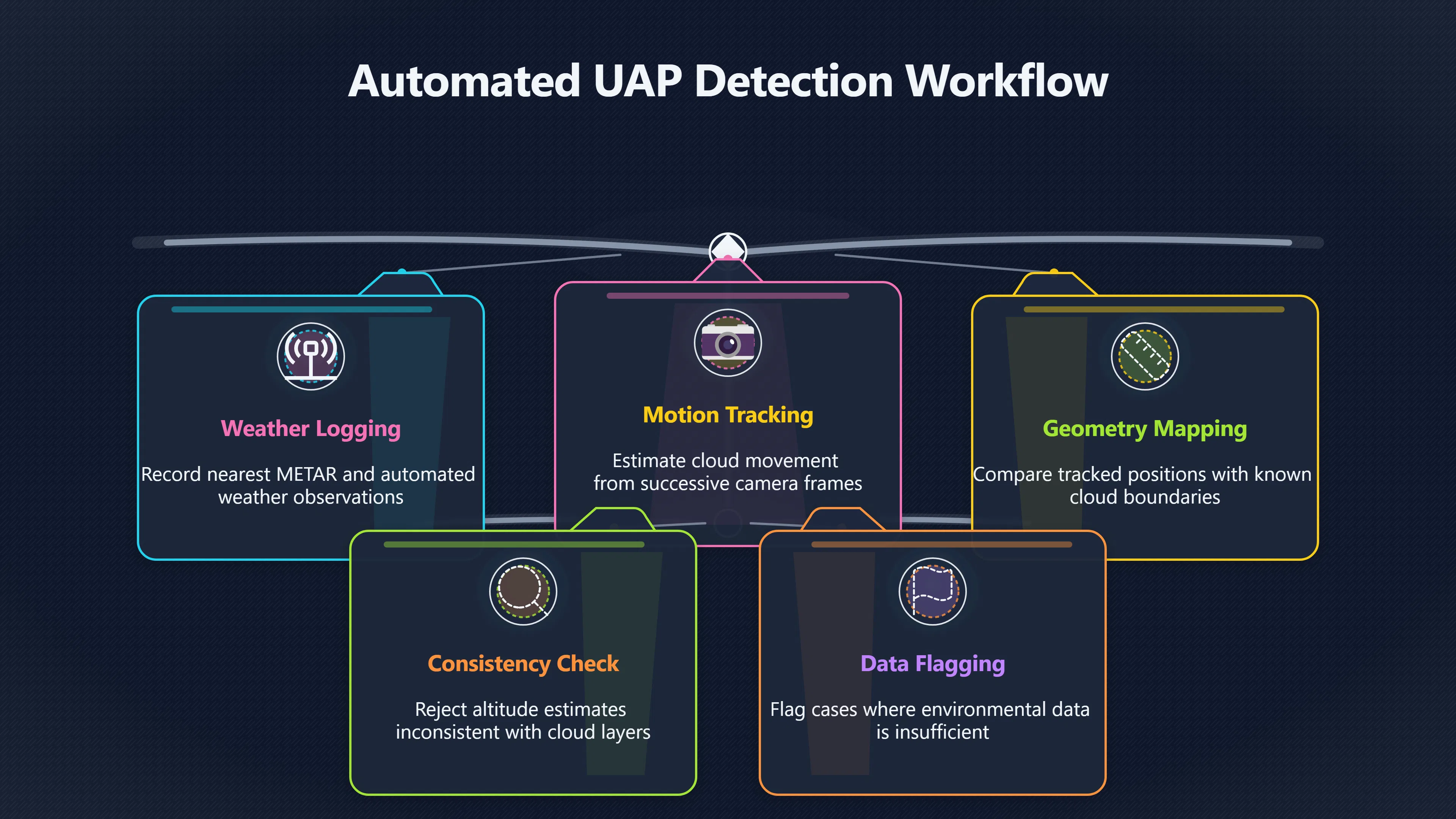
How automated UAP detectors can use cloud information
For an automated instrumented detector, cloud information is most valuable when integrated directly into the event record rather than consulted afterwards.
A robust workflow typically includes:
- Recording the nearest METAR or automated weather observation at the event time.
- Logging measured cloud base, cloud ceiling and visibility. [pprune.org]pprune.org537402 cloud base vs cloud ceilingCloud base vs Cloud ceiling5 Apr 2014 — Clouds, in a METAR have their bases defined as height above ground level. That's for all clouds r…
- Estimating cloud motion from successive camera frames or weather data.
- Comparing tracked object position with cloud boundaries in image coordinates.
- Rejecting altitude estimates that are geometrically inconsistent with measured cloud layers.
- Flagging cases where cloud interaction cannot be explained because the available environmental data are insufficient.
Where higher precision is required, additional sources such as local ceilometers, weather radar, satellite cloud imagery or multiple synchronised cameras can improve reconstruction of cloud geometry. NASA’s independent UAP study specifically highlighted the value of integrating environmental observations with calibrated sensor metadata to improve scientific assessment of reported events. [NASA Science]science.nasa.govNASA ScienceUAPJune 16, 2022 — 9 Jun 2022 — The study will focus on identifying available data, how best to collect future data, and how…

What cloud checks can and cannot prove
Cloud measurements are powerful constraints but not direct identifiers.
They can often demonstrate that:
- a claimed altitude is physically implausible;
- an object could not have occupied the reported position;
- disappearance is consistent with cloud obscuration;
- witness estimates of distance were probably incorrect.
They cannot, however, determine the object’s identity by themselves. A cloud layer cannot distinguish between an aircraft, balloon, drone or genuinely unidentified object if all remain geometrically consistent with the available measurements.
For this reason, cloud-height analysis works best as one component within a multi-sensor system. Combined with calibrated cameras, timing, weather observations and independent tracking data, it transforms subjective impressions such as “it flew through the clouds” into testable hypotheses constrained by measurable atmospheric conditions.
Amazon book picks
Further Reading
Books and field guides related to Can clouds expose a false altitude?. Use these as the next step if you want deeper reading beyond the article.
The AMS Weather Book
Explains cloud types, cloud bases, visibility, and atmospheric conditions that underpin cloud-height reality checks.
Weather Flying
Focuses on cloud bases, ceilings, visibility, and practical interpretation of weather conditions when judging altitude and distance.
A Visual Guide to Weather and Climate
Provides clear explanations of cloud layers, atmospheric phenomena, and weather observation concepts useful for interpreting sky scenes.
The Weather Handbook
Helps readers understand cloud behavior, visibility, and atmospheric conditions that can affect perceived object altitude.
eBay marketplace picks
Marketplace Samples
Live-tested eBay searches with available results related to this page.


Endnotes
-
Source: science.nasa.gov
Link: https://science.nasa.gov/uap/Source snippet
NASA ScienceUAPJune 16, 2022 — 9 Jun 2022 — The study will focus on identifying available data, how best to collect future data, and how...
Published: June 16, 2022
-
Source: boldmethod.com
Link: https://www.boldmethod.com/learn-to-fly/weather/cloud-ceilings-celestial-dome/Source snippet
rs use trigonometry and a light beam to determine cloud...Read more...
-
Source: weather.gov
Title: National Weather Service Why NWS Needs Your Pilot Reports
Link: https://www.weather.gov/media/publications/front/09dec-front.pdfSource snippet
OVC040 = Overcast at 4,000 ft above the airport. If the airport is 1,000 ft, cloud bases are...Read more...
-
Source: earthdata.nasa.gov
Title: cloud cover conundrum new study helps improve cloud predictions atmospheric
Link: https://www.earthdata.nasa.gov/news/feature-articles/cloud-cover-conundrum-new-study-helps-improve-cloud-predictions-atmosphericSource snippet
Cover Conundrum: New Study Helps Improve...27 Jan 2026 — Cloud Cover Conundrum: New Study Helps Improve Cloud Predictions in Atmospheric...
-
Source: weather.metoffice.gov.uk
Link: https://weather.metoffice.gov.uk/guides/observations/how-we-measure-cloudSource snippet
Met OfficeHow we measure cloudTake a look at how we observe the type, amount and height of clouds. The large scale distribution of cloud...
-
Source: tarmacview.com
Title: cloud base
Link: https://www.tarmacview.com/glossary/cloud-base/Source snippet
Airport Lights InspectionCloud Base | Airport Lights Inspection18 Nov 2025 — Cloud base is the lowest visible altitude of a cloud or clou...
Additional References
-
Source: primitiveproton.com
Link: https://primitiveproton.com/unidentified-anomalous-phenomena-uap/ -
Source: researchgate.net
Link: https://www.researchgate.net/publication/376519968_An_environmental_analysis_of_public_UAP_sightings_and_sky_view_potentialSource snippet
An environmental analysis of public UAP sightings and sky...8 Dec 2023 — In this study, we develop a new near-global, fine-grain (≈1 km)...
-
Source: avi-loeb.medium.com
Title: a new calculation on the fly to the nasa uap study 2dacaf860cac
Link: https://avi-loeb.medium.com/a-new-calculation-on-the-fly-to-the-nasa-uap-study-2dacaf860cacSource snippet
New Calculation on the Fly to the NASA UAP Study - Avi LoebThe NASA Study will examine unclassified data on UAP in an attempt to separate...
-
Source: universalweather.com
Title: aviation weather tips all you need to know about ceilings
Link: https://www.universalweather.com/blog/aviation-weather-tips-all-you-need-to-know-about-ceilings/Source snippet
Understanding Ceiling Conditions and Flight Impacts29 Jul 2025 — Ceiling conditions—referring to the height of a cloud base above the gro...
-
Source: space.com
Title: nasa ufo uap study team first results revealed
Link: https://www.space.com/nasa-ufo-uap-study-team-first-results-revealedSource snippet
NASA UFO report finds no evidence of 'extraterrestrial...14 Sept 2023 — NASA's UFO study team released its long-awaited first report tod...
-
Source: instagram.com
Link: https://www.instagram.com/reel/DPEKxPHjHRe/?hl=enSource snippet
ling = the lowest layer that's reported as broken or overcast (the...
-
Source: youtube.com
Title: Cloud Base Calculator — How to Use It | Engineering Tool
Link: https://www.youtube.com/watch?v=ZyYf_oNKGFQSource snippet
Essential Pilot Math Series | Lesson 12: Cloud Base Height - YouTube Essential Pilot Math Series | Lesson 12: Cloud Base Height - YouTube...
-
Source: sciencenews.org
Title: scientists serious ufo uap security
Link: https://www.sciencenews.org/article/scientists-serious-ufo-uap-securitySource snippet
Scientists are getting serious about UFOs. Here's why7 Aug 2024 — UFOs have been rebranded as unexplained anomalous phenomena, or UAPs, a...
-
Source: pprune.org
Title: 537402 cloud base vs cloud ceiling
Link: https://www.pprune.org/questions/537402-cloud-base-vs-cloud-ceiling.htmlSource snippet
Cloud base vs Cloud ceiling5 Apr 2014 — Clouds, in a METAR have their bases defined as height above ground level. That's for all clouds r...
-
Source: youtube.com
Link: https://www.youtube.com/watch?v=Ttapu-_9zcISource snippet
Here are some tools to help you plan an altitude free of clouds...
Topic Tree