Within Calibration
How planes turn pixels into sky measurements
Known aircraft can turn a sky camera from a recorder into a measuring instrument by tying pixels to real directions and times.
On this page
- Why a camera needs real world pointing checks
- How aircraft tracks map pixels to azimuth and elevation
- What repeated aircraft passes reveal over time
Page outline Jump by section
Introduction
In an automated instrumented UFO detector, a passing aircraft is more than a known object to be filtered out. It can become a moving calibration target that helps transform a camera from a device that merely records images into an instrument that measures positions in the sky. The key advantage is that many aircraft continuously broadcast their location, altitude, velocity, and identity through Automatic Dependent Surveillance–Broadcast (ADS-B), creating an independent record of where they should appear in a camera’s field of view. By comparing those known positions with observed pixels, a sky-monitoring system can verify its pointing, correct alignment errors, and measure how accurately it translates images into real-world directions. [Textron Aviation]txtav.comTextron AviationADS-B Out ExplainedADS-B allows equipped aircraft and ground vehicles to broadcast their identification, position, altitu…
 For systems intended to detect unusual aerial phenomena, this capability is crucial. Before any object can be judged anomalous, the detector must demonstrate that it can reliably map ordinary aircraft to the correct locations in the sky. Aircraft therefore act as continuously available reference points that test the camera under real operating conditions rather than laboratory conditions alone. [arXiv]arxiv.orgCommissioning An All-Sky Infrared Camera Array for Detection Of Airborne ObjectsNovember 12, 2024…
Why a camera needs real-world pointing checks
A camera image is fundamentally a grid of pixels. On its own, a pixel coordinate does not reveal a direction in the sky. To measure an object’s position, the system must know exactly how the camera is oriented, how its lens distorts incoming light, and how image coordinates correspond to azimuth and elevation angles.
Even a carefully installed camera can drift. Temperature changes can slightly alter lens geometry. Wind can shift mounts. Mechanical settling can change orientation over time. Wide-angle and fisheye lenses often introduce substantial distortion near the edges of the field of view, making calibration especially important for all-sky monitoring systems. Astronomical all-sky camera research routinely treats accurate astrometric calibration as a major challenge because distortion and orientation errors can translate into large positional mistakes if left uncorrected. [A&A+2ilrs.gsfc.nasa.gov]aanda.orgaa35580 19A&AAstrometric calibration for all-sky cameras revisitedby D Barghini · 2019 · Cited by 26 — The astrometric calibration of an all-sky ca…
Traditional observatories often use stars for calibration because stellar positions are known with extreme precision. However, aircraft provide a complementary advantage for aerial surveillance systems: they move through the same airspace that the detector is intended to monitor. They therefore test not only pointing accuracy but also detection algorithms, tracking software, timing synchronisation, and object classification pipelines. [arXiv]arxiv.orgCommissioning An All-Sky Infrared Camera Array for Detection Of Airborne ObjectsNovember 12, 2024…
How aircraft tracks map pixels to azimuth and elevation
The calibration mechanism is conceptually straightforward.
An ADS-B-equipped aircraft broadcasts its position and altitude. From the detector’s location on the ground, those coordinates can be converted into the aircraft’s expected azimuth, elevation angle, and range at a given moment. The camera simultaneously records the aircraft as a bright point or moving object in a sequence of frames. If the calibration is correct, the predicted sky position and observed pixel position should agree. [Textron Aviation+2Analog Devices Wiki]txtav.comTextron AviationADS-B Out ExplainedADS-B allows equipped aircraft and ground vehicles to broadcast their identification, position, altitu…
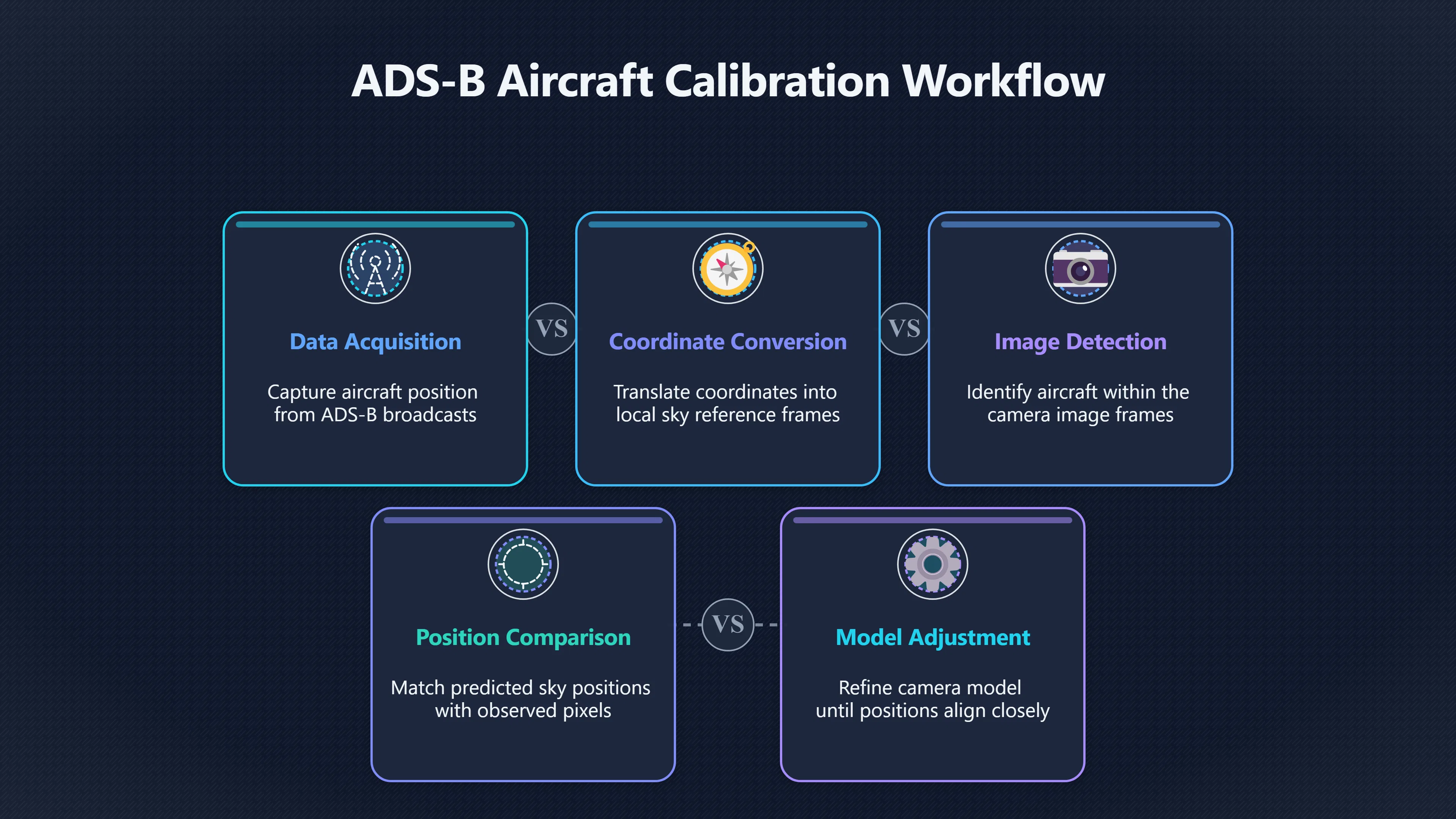
The process typically involves several stages:
- Acquire aircraft position data from ADS-B broadcasts.
- Convert aircraft coordinates into the local sky reference frame.
- Detect the aircraft in camera images using tracking or machine-learning methods.
- Compare predicted and observed locations.
- Adjust the camera model until prediction and observation align as closely as possible.
This effectively turns each aircraft into a moving calibration marker whose position is independently known. Unlike fixed calibration targets, aircraft cross different regions of the image and therefore probe multiple parts of the lens and sensor geometry. [MDPI]mdpi.comThe ADS-B…
The approach has moved beyond theory. The Galileo Project’s all-sky infrared observatory reported a dedicated extrinsic calibration method that uses airplane positions obtained from locally collected ADS-B data. Their calibration pipeline matches aircraft detections in infrared imagery with predicted positions derived from ADS-B trajectories and uses those matches to refine camera orientation. [arXiv]arxiv.orgCommissioning An All-Sky Infrared Camera Array for Detection Of Airborne ObjectsNovember 12, 2024…

Why moving targets are often better than fixed ones
A stationary calibration object only verifies a limited part of an image. Aircraft provide a richer test because they sweep through many viewing angles and elevations.
A single airliner on approach may move from low elevation near the horizon to a much higher angle in the sky. Over that trajectory it samples different parts of the lens, exposing distortions that would be difficult to identify from a fixed reference point alone. Multiple aircraft travelling on different routes create an even denser calibration network. [MDPI]mdpi.comThe ADS-B…
Moving targets also test timing. If camera timestamps are inaccurate, a predicted aircraft position and observed position will diverge along the direction of motion. This allows operators to identify clock offsets and synchronisation problems that might otherwise masquerade as tracking errors. The Galileo Project’s commissioning work explicitly accounted for timing uncertainties when matching ADS-B predictions with image detections. [MDPI]mdpi.comThe ADS-B…
For automated UFO detection, this is especially valuable because many apparent anomalies arise from geometry and timing misunderstandings rather than unusual object behaviour.
What repeated aircraft passes reveal over time
The greatest value emerges when calibration is not treated as a one-time procedure.
A detector operating for weeks or months can accumulate thousands of aircraft tracks. Repeated comparisons between ADS-B predictions and image detections create a long-term record of instrument performance. Systematic offsets become visible. A camera that slowly shifts orientation can be identified because aircraft begin appearing consistently displaced from their predicted locations. [MDPI]mdpi.comThe ADS-B…
The Galileo Project’s commissioning work illustrates this idea. Their procedure collects observations from multiple aircraft before computing updated orientation solutions, allowing the system to monitor and correct changes in camera pointing. Rather than assuming the camera remains perfectly aligned forever, aircraft become a continual health check on the instrument. [MDPI]mdpi.comThe ADS-B…
Long-term aircraft observations can reveal:
- Gradual mount movement.
- Thermal expansion effects.
- Lens or sensor alignment drift.
- Timestamp errors.
- Detection algorithm weaknesses.
- Parts of the field of view where positional accuracy deteriorates.
Because commercial air traffic is abundant in many regions, these checks can occur naturally without deploying specialised calibration hardware. [ADS-B Exchange]adsbexchange.comADS-B ExchangeADS-B ExchangeADS-B help Aircraft use ADS-B (Automatic Dependent Surveillance-Broadcast) to transmit their position and fli…

What this means for automated UFO detectors
The central lesson is that ordinary aircraft provide a measurable bridge between image space and physical space. When a detector repeatedly demonstrates that known aircraft appear exactly where independent tracking data says they should appear, confidence increases that the system is correctly interpreting the sky.
This does not guarantee that every unidentified object is extraordinary. Instead, it establishes something more fundamental: that the detector’s measurements have a verified relationship to reality. A reported bearing, elevation, angular velocity, or trajectory becomes more credible because the same system has already been tested against thousands of independently tracked aircraft. [arXiv+2World Scientific]arxiv.orgCommissioning An All-Sky Infrared Camera Array for Detection Of Airborne ObjectsNovember 12, 2024…
In that sense, aircraft are not merely clutter to be removed from UFO databases. They are moving calibration standards that continuously demonstrate whether a sky-monitoring camera is functioning as a scientific instrument or merely collecting images. [arXiv]arxiv.orgCommissioning An All-Sky Infrared Camera Array for Detection Of Airborne ObjectsNovember 12, 2024…
Amazon book picks
Further Reading
Books and field guides related to How planes turn pixels into sky measurements. Use these as the next step if you want deeper reading beyond the article.
Introduction to Modern Photogrammetry
Strong match for converting pixel locations into azimuth, elevation, and geometric measurements.

Digital Image Processing, Global Edition
First published 2018. Subjects: Image processing, digital techniques.

Multiple view geometry in computer vision
First published 2000. Subjects: Computer vision, Projective Geometry, Geometry, modern.

Computer Vision
First published 2010. Subjects: Computer algorithms, Bildverarbeitung, Computer vision, Image processing, Maschinelles Sehen.
eBay marketplace picks
Marketplace Samples
Example marketplace items related to this page. Use the search link to explore similar finds on eBay.


Endnotes
-
Source: arxiv.org
Link: https://arxiv.org/abs/2411.07956Source snippet
Commissioning An All-Sky Infrared Camera Array for Detection Of Airborne ObjectsNovember 12, 2024...
Published: November 12, 2024
-
Source: aanda.org
Title: aa35580 19
Link: https://www.aanda.org/articles/aa/full_html/2019/06/aa35580-19/aa35580-19.htmlSource snippet
A&AAstrometric calibration for all-sky cameras revisitedby D Barghini · 2019 · Cited by 26 — The astrometric calibration of an all-sky ca...
-
Source: ilrs.gsfc.nasa.gov
Link: https://ilrs.gsfc.nasa.gov/lw22/posters/papers/S06-P13_Jose_Rodriguez_Paper.pdfSource snippet
in operational GUIs with predicted [satellites]({{ 'satellites/' | relative_url }}) or ADS-B relayed aircraft) as...Read more...
-
Source: wiki.analog.com
Link: https://wiki.analog.com/resources/eval/user-guides/picozed_sdr/tutorials/adsbSource snippet
Analog Devices WikiADS-B Airplane Tracking Tutorial30 Jan 2023 — Commercial aircraft use ADS-B transmitters to report their position, vel...
-
Source: mdpi.com
Link: https://www.mdpi.com/1424-8220/25/3/783Source snippet
The ADS-B...
-
Source: ntrs.nasa.gov
Title: JAIS Detection and Tracking of Aircraft Systems R1b4
Link: https://ntrs.nasa.gov/api/citations/20210010503/downloads/JAIS%20Detection%20and%20Tracking%20of%20Aircraft%20%20Systems%20R1b4.pdfSource snippet
and Tracking of Aircraft in the Far-Field from...by CV Dolph · 2021 · Cited by 18 — –Broadcast (ADS-B), A 100-pixel radius corresponds t...
-
Source: youtube.com
Title: Why Scientists Stopped LISTENING For Aliens
Link: https://www.youtube.com/watch?v=sA376ly2cvoSource snippet
The Galileo Project...
-
Source: youtube.com
Title: The Galileo Project
Link: https://www.youtube.com/watch?v=YSxF8SuTBtU -
Source: txtav.com
Link: https://txtav.com/en/journey/articles/articles/adsb-out-explainedSource snippet
Textron AviationADS-B Out ExplainedADS-B allows equipped aircraft and ground vehicles to broadcast their identification, position, altitu...
-
Source: adsbexchange.com
Link: https://www.adsbexchange.com/Source snippet
ADS-B ExchangeADS-B ExchangeADS-B help Aircraft use ADS-B (Automatic Dependent Surveillance-Broadcast) to transmit their position and fli...
-
Source: worldscientific.com
Link: https://www.worldscientific.com/doi/10.1142/S2251171723400020?srsltid=AfmBOormwXo-osRWw_QJzbIAbgoB7AdoQrWvMuS1j1ckl6ez-c8inn2gSource snippet
4.2.1). •. We...
-
Source: ui.adsabs.harvard.edu
Link: https://ui.adsabs.harvard.edu/abs/arXiv%3A2411.07956Source snippet
an All-Sky Infrared Camera Array for...In addition to performing intrinsic and thermal calibrations, we implement a novel extrinsic cali...
Additional References
-
Source: researchgate.net
Link: https://www.researchgate.net/publication/388466760_Commissioning_an_All-Sky_Infrared_Camera_Array_for_Detection_of_Airborne_ObjectsSource snippet
(PDF) Commissioning an All-Sky Infrared Camera Array for...10 Jan 2025 — In addition to performing intrinsic and thermal calibrations, w...
-
Source: raspberrypi.com
Link: https://www.raspberrypi.com/tutorials/build-your-own-raspberry-pi-flight-tracker/Source snippet
Build your own Raspberry Pi flight trackerReceive signals from aircraft transponders and track flights with a Raspberry Pi 3 A+ and a low...
-
Source: avi-loeb.medium.com
Link: https://avi-loeb.medium.com/commissioning-data-on-half-a-million-objects-in-the-sky-from-the-galileo-project-observatory-are-a23bd084233aSource snippet
Data on Half a Million Objects in the Sky from...Airplane positions from Automatic Dependent Surveillance–Broadcast (ADS-B) data was col...
-
Source: thedebrief.org
Link: https://thedebrief.org/galileo-project-releases-commissioning-data-on-half-a-million-aerial-objects-are-any-of-them-uap/Source snippet
Galileo Project Releases Commissioning Data on Half a...12 Nov 2024 — The Galileo Project has released the commissioning data from its f...
-
Source: sgf.rgo.ac.uk
Link: https://sgf.rgo.ac.uk/operations/adsb.htmlSource snippet
rgo.ac.ukADS-B technology informs the SGF in-sky aircraft safety systemThe latitudes, longitudes and altitudes are converted to in-sky az...
-
Source: youtube.com
Link: https://www.youtube.com/watch?v=cKrW0aoB_6wSource snippet
ADS-B: The Future of Aircraft Surveillance! Explained by...ADSB is an advanced surveillance technology that allows aircraft to broadcast...
-
Source: la.mathworks.com
Title: simulate and track en route air traffic with earth centered scenarios
Link: https://la.mathworks.com/help/fusion/ug/simulate-and-track-en-route-air-traffic-with-earth-centered-scenarios.htmlSource snippet
In this section, you simulate the scenario and step the [radar]({{ 'radar/' | relative_url }}) tracker, track fuser, ADS-B transponder, and receiver. %...Read more...
-
Source: discussions.flightaware.com
Title: finding altitude azimuth of flight for telescope
Link: https://discussions.flightaware.com/t/finding-altitude-azimuth-of-flight-for-telescope/61483Source snippet
FlightAware DiscussionsFinding altitude, azimuth of flight for telescope26 Feb 2020 — My goal would be to find all flight traffic in a re...
-
Source: discussions.flightaware.com
Title: interesting ads b broadcasts what are they
Link: https://discussions.flightaware.com/t/interesting-ads-b-broadcasts-what-are-they/98186Source snippet
ADS-B broadcasts... What are they?5 May 2025 — Typically a radar/surveillance aircraft: Are aircraft/balloons at 120,000 being detected o...
Published: May 2025
-
Source: researchgate.net
Title: 317599939 Large Scale ADS B Data and Signal Quality Analysis
Link: https://www.researchgate.net/publication/317599939_Large-Scale_ADS-B_Data_and_Signal_Quality_AnalysisSource snippet
Galileo Project is designing, building, and commissioning a...
Topic Tree