Within Metadata
Where Was the Camera Really Pointing?
A light facing west at sunset, north over an airport or upward near clouds leads analysts toward very different candidate explanations.
On this page
- Direction, elevation and the line of sight
- Why landmarks and horizons matter
- How fixed stations record pointing automatically
Page outline Jump by section
Introduction
A UFO video becomes much easier to analyse when investigators know not only where the camera was located, but exactly where it was pointing. The camera’s horizontal direction (azimuth), vertical angle (elevation), and line of sight often narrow the list of possible explanations far more effectively than the apparent shape of the object itself. A bright light filmed low in the western sky shortly after sunset suggests a very different set of candidates than a light recorded high overhead, facing north, near an airport approach corridor. In many cases, the difference between an unexplained sighting and an ordinary explanation comes down to a few missing degrees of camera orientation. NASA’s UAP study highlighted the broader problem: many reports lack the sensor metadata needed to reconstruct what was actually observed. [NASA Science]science.nasa.govNASA ScienceIndependent Study Team ReportAt present, analysis of UAP data is hampered by poor sensor calibration, the lack of multiple me…
 For automated instrumented UFO detectors, recording pointing information is therefore not an optional extra. It is a core measurement that allows later analysts to compare a sighting against aircraft tracks, satellite positions, astronomical objects, weather conditions, and other sensors observing the same part of the sky.
Where Was the Camera Really Pointing?
Direction, elevation and the line of sight
Every observation defines a line of sight extending from the camera into the sky. Without knowing that line, an analyst cannot reliably determine what objects were located in the observed region.
Three measurements matter most:
- Azimuth: the compass direction the camera faced.
- Elevation: the angle above the horizon.
- Time: the moment that direction was observed.
Together, these values define a specific patch of sky. Once known, they can be compared with aircraft transponder data, satellite ephemerides, astronomical catalogues, weather observations, and other sensor records.
The importance of line-of-sight geometry is well established in surveillance, astronomy, and tracking systems. A sensor’s ability to observe an object depends not merely on range, but on the exact geometric relationship between observer and target. Terrain, horizon position, viewing angle, and object altitude all affect what can be seen and how it appears. [Counter UAV Radar]counteruavradar.comCounter UAV Radar What is Line of Sight in Surveillance?Counter UAV RadarSeptember 8, 2025 — 8 Sept 2025 — A beginner-friendly guide to what line of sight means in surveillance, why nominal ran…
This is why the same bright light can produce entirely different hypotheses depending on where the camera was aimed:
- West near sunset: analysts may examine illuminated aircraft, high-altitude balloons, satellites entering sunlight, or bright planets visible in twilight.
- North over an airport approach path: aircraft landing lights become a leading candidate.
- High overhead near the zenith: satellites, meteors, or astronomical objects become more relevant.
- Low over a distant ridge or cloud bank: atmospheric effects, reflections, and misjudged distances become more plausible.
Without pointing information, all of these possibilities remain mixed together.
Why apparent behaviour changes with viewing angle
Camera direction also affects how motion is interpreted.
An object moving directly toward the observer may appear almost stationary. The same object crossing the line of sight can appear to move rapidly across the frame. This basic geometric effect means that apparent speed and manoeuvrability cannot be judged reliably without reconstructing the viewing direction.
A light near the horizon may also seem to hover because distant objects change position slowly relative to foreground landmarks. Conversely, an object viewed against nearby clouds can appear to accelerate dramatically if the clouds themselves are moving or if the camera is panning.
Knowing the camera’s orientation allows analysts to model these geometric effects rather than relying on visual impressions alone.
Why Landmarks and Horizons Matter
One of the fastest ways to recover pointing information from a video is through visible landmarks.
Buildings, mountains, coastlines, roads, towers, and distinctive terrain features can often be matched to maps. Once matched, investigators can estimate camera orientation and reconstruct the observed sky region.
The horizon is especially valuable. In imaging science and navigation, horizon position is routinely used to estimate camera attitude and orientation. Researchers have demonstrated that horizon geometry can be used to infer viewing direction and improve orientation estimates even when other reference information is unavailable. [ResearchGate]researchgate.netResearchGate(PDF) Automatic orientation of historical terrestrial images…November 1, 2022 — In a first step, the whole horizon was use…
For UFO analysis, the horizon provides several benefits:
- It establishes whether the object was near the horizon or high in the sky.
- It allows estimation of elevation angle.
- It helps distinguish atmospheric phenomena from high-altitude objects.
- It provides scale and reference points for measuring apparent motion.
A cropped video that removes the horizon often eliminates exactly the information needed to determine whether an object was hundreds of metres away or hundreds of kilometres away.
This is why experienced analysts frequently seek the uncropped original footage rather than a zoomed-in social-media clip. The surroundings often contain more useful information than the object itself.

A practical example
Imagine two videos showing an identical bright point of light.
In the first video, later investigation reveals the camera was facing west at an elevation of 8 degrees shortly after sunset. Astronomical and satellite databases show several sunlit satellites passing through that region at the recorded time.
In the second video, the camera was facing north-east at 25 degrees elevation near a major airport. Flight-tracking records show a commercial aircraft approaching on a standard arrival route.
The visible object may look almost identical in both clips. The explanation changes because the viewing geometry changes.

How Fixed Stations Record Pointing Automatically
Automated instrumented UFO detector networks attempt to eliminate this uncertainty by recording pointing information continuously and automatically.
Modern astronomical and meteor-monitoring systems provide useful examples. Many all-sky camera networks calibrate their cameras against known star positions so that every pixel corresponds to a precise azimuth and elevation in the sky. This process is known as astrometric calibration. Once calibrated, analysts can determine exactly where an observed object appeared in the celestial sphere. [A&A]aanda.orgaa35580 19a dedicated astrometric reduction is needed. azimuth (a)…
Meteor networks routinely rely on this capability. Systems such as CAMS and other multi-station monitoring networks use calibrated cameras to convert image positions into precise sky coordinates and trajectories. [SETI Cams+2SETI Institute]cams.seti.orgCams Cameras for Allsky Meteor Surveillance to establishby P Jenniskens · 2011 · Cited by 286 — Sixty video cameras at three stations monitor the sky above 31° elevation. Goal of CAMS is to…
More advanced systems go further by automatically determining orientation relative to true north and the horizon using star tracking and calibration routines. Some modern all-sky imaging systems can continuously update camera orientation without human intervention, maintaining accurate azimuth and elevation references over long deployments. [arXiv]arxiv.orgAuto-Cal: Automated and Continuous Geo-Referencing of All-Sky Imagers Using Fisheye Lens Modeling and Star TracksAugust 23, 2025…
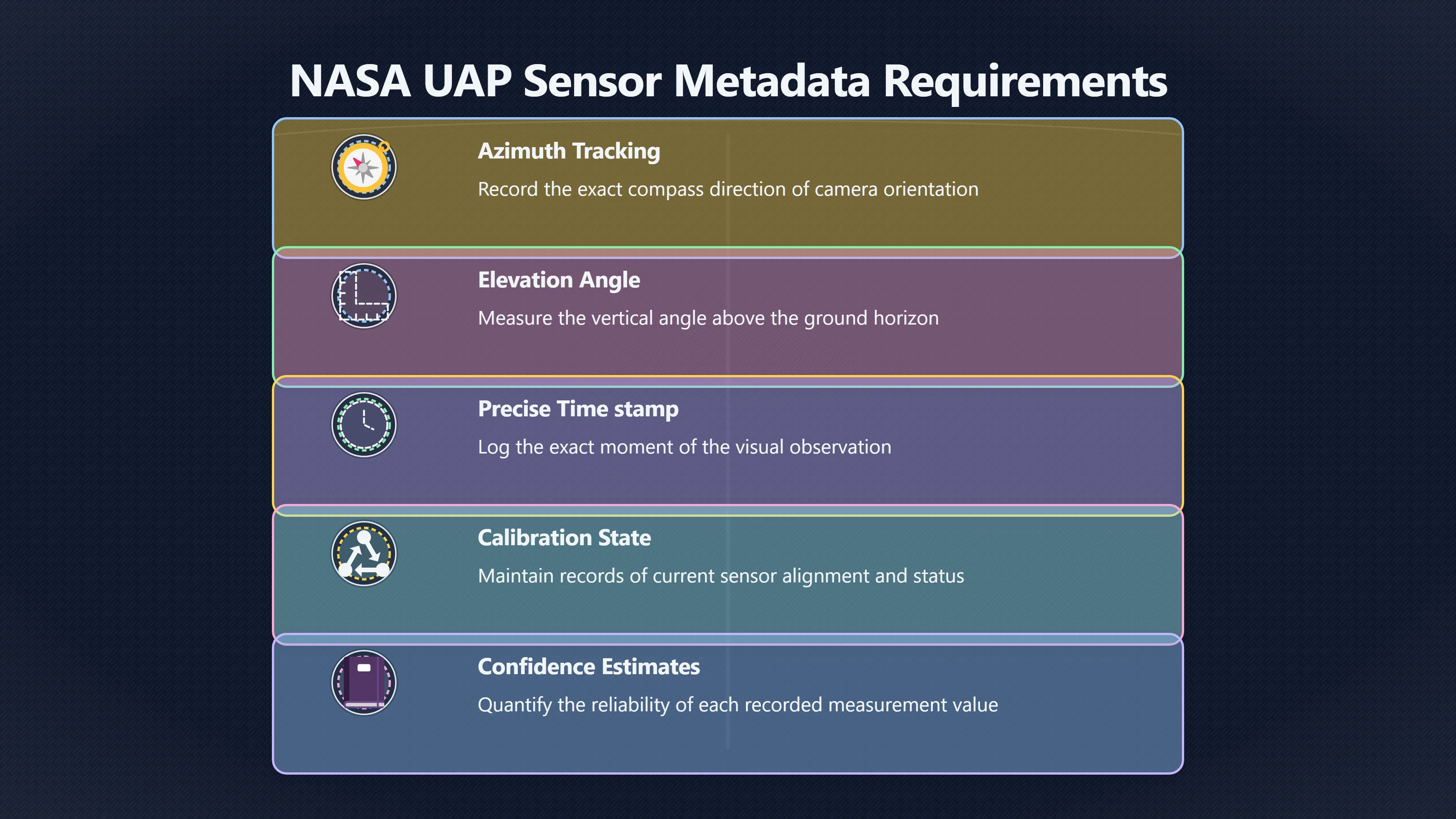
For a UFO detector, this means every detected object can be stored with:
- Exact timestamp.
- Observer location.
- Azimuth.
- Elevation.
- Camera calibration state. [ilrs.gsfc.nasa.gov]ilrs.gsfc.nasa.govin operational GUIs with predicted satellites or ADS-B relayed aircraft) as…Read more…
- Confidence estimates for the measurement.
That metadata transforms a video from a visual anecdote into a measurable observation.
Why Pointing Data Matters for Multi-Sensor Confirmation
The value of pointing information increases dramatically when multiple stations are involved.
If two calibrated cameras at different locations record the same object and both provide accurate lines of sight, analysts can triangulate its position and estimate distance. Once distance is known, apparent motion can be converted into real motion. Objects that seemed extraordinary in a single video often become easier to classify when their actual altitude and trajectory are measured. [Naval Postgraduate School]nps.eduNaval Postgraduate SchoolUnidentified Anomalous Phenomena: Science and Analysis4 days ago — Range can be estimated from triangulating lin…
This is one reason NASA’s UAP study emphasised calibrated sensors, multiple measurements, and complete metadata. Better observations are not simply a matter of higher-resolution cameras; they require knowing exactly what the sensor was doing and where it was looking. [NASA Science+2Wikisource]science.nasa.govNASA ScienceIndependent Study Team ReportAt present, analysis of UAP data is hampered by poor sensor calibration, the lack of multiple me…
In practical terms, a camera’s pointing direction is often the key that unlocks every subsequent analysis. Without it, investigators are left guessing which part of the sky they are examining. With it, they can begin testing explanations against measurable reality.
Amazon book picks
Further Reading
Books and field guides related to Where Was the Camera Really Pointing?. Use these as the next step if you want deeper reading beyond the article.
Turn Left at Orion
Helps identify landmarks and regions of the sky from viewing direction and time.
How to Lie with Statistics
Illustrates how incomplete information and missing context can produce misleading conclusions.

Digital SLR Astrophotography
First published 2007. Subjects: Photography, digital techniques, Astronomical photography.
Practical Astronomy with Your Calculator Or Spreadsheet
Provides methods for calculating object positions from time and viewing geometry.
eBay marketplace picks
Marketplace Samples
Live-tested eBay searches with available results related to this page.

Endnotes
-
Source: science.nasa.gov
Link: https://science.nasa.gov/wp-content/uploads/2023/09/uap-independent-study-team-final-report.pdfSource snippet
NASA ScienceIndependent Study Team ReportAt present, analysis of UAP data is hampered by poor sensor calibration, the lack of multiple me...
-
Source: nasa.gov
Title: update nasa shares uap independent study report names director
Link: https://www.nasa.gov/news-release/update-nasa-shares-uap-independent-study-report-names-director/Source snippet
UPDATE: NASA Shares UAP Independent Study Report14 Sept 2023 — We found that NASA can help the whole-of-government UAP effort through sys...
-
Source: researchgate.net
Link: https://www.researchgate.net/publication/365334026_Automatic_orientation_of_historical_terrestrial_images_in_mountainous_terrain_using_the_visible_horizonSource snippet
ResearchGate(PDF) Automatic orientation of historical terrestrial images...November 1, 2022 — In a first step, the whole horizon was use...
Published: November 1, 2022
-
Source: aanda.org
Title: aa35580 19
Link: https://www.aanda.org/articles/aa/full_html/2019/06/aa35580-19/aa35580-19.htmlSource snippet
a dedicated astrometric reduction is needed. azimuth (a)...
-
Source: ilrs.gsfc.nasa.gov
Link: https://ilrs.gsfc.nasa.gov/lw22/posters/papers/S06-P13_Jose_Rodriguez_Paper.pdfSource snippet
in operational GUIs with predicted satellites or [ADS-B]({{ 'ads-b/' | relative_url }}) relayed aircraft) as...Read more...
-
Source: cams.seti.org
Title: Cams Cameras for Allsky Meteor Surveillance to establish
Link: https://cams.seti.org/CAMSoverviewpaper.pdfSource snippet
by P Jenniskens · 2011 · Cited by 286 — Sixty video cameras at three stations monitor the sky above 31° elevation. Goal of CAMS is to...
-
Source: seti.org
Link: https://www.seti.org/projects/cams/Source snippet
SETI InstituteCameras for Allsky Meteor Surveillance (CAMS)The CAMS network uses an array of low-light video surveillance cameras positio...
-
Source: arxiv.org
Title: arXiv A Multi-station Meteor Monitoring (M$^3$) System. I. Design and Testing
Link: https://arxiv.org/abs/2409.19503 -
Source: arxiv.org
Link: https://arxiv.org/abs/2508.17146Source snippet
Auto-Cal: Automated and Continuous Geo-Referencing of All-Sky Imagers Using Fisheye Lens Modeling and Star TracksAugust 23, 2025...
Published: August 23, 2025
-
Source: arxiv.org
Link: https://arxiv.org/html/2501.08358v1Source snippet
these images can exceed 180 degrees, readily recording atmospheric...
-
Source: en.wikisource.org
Title: Responses to Statement of Task
Link: https://en.wikisource.org/wiki/NASA_Unidentified_Anomalous_Phenomena%3A_Independent_Study_Team_Report/Responses_to_Statement_of_TaskSource snippet
Unidentified Anomalous Phenomena: Independent...14 Oct 2023 — Indeed, several apparent UAP have been demonstrated to be sensor artifacts...
-
Source: science.nasa.gov
Link: https://science.nasa.gov/uap/Source snippet
nasa.govUAP9 Jun 2022 — The study will focus on identifying available data, how best to collect future data, and how NASA can use that da...
-
Source: ntrs.nasa.gov
Link: https://ntrs.nasa.gov/citations/20210007696Source snippet
Illuminated Feature Position Determination...by JY Liu · 2017 — This paper describes several approaches for the calibration of translati...
-
Source: en.wikisource.org
Title: Page:UAP Independent Study Team Final Report
Link: https://en.wikisource.org/wiki/Page%3AUAP_Independent_Study_Team_-_Final_Report.pdf/15Source snippet
wikisource.orgPage:UAP Independent Study Team - Final Report.pdf/1512 Nov 2023 — Indeed, several apparent UAP have been demonstrated to b...
-
Source: arxiv.org
Link: https://arxiv.org/html/2411.07956v1Source snippet
1 Introduction12 Nov 2024 — In 2023, NASA released an independent study Team (2023) which emphasized how studying the phenomenon using pa...
-
Source: researchgate.net
Link: https://www.researchgate.net/publication/367076053_The_Scientific_Investigation_of_Unidentified_Aerial_Phenomena_UAP_Using_Multimodal_Ground-based_ObservatoriesSource snippet
The Scientific Investigation of Unidentified Aerial...23 May 2026 — Current data, often collected by instruments not calibrated for scie...
Published: May 2026
-
Source: researchgate.net
Title: 377844698 Investigating UAP Events Using Astronomical Techniques
Link: https://www.researchgate.net/publication/377844698_Investigating_UAP_Events_Using_Astronomical_TechniquesSource snippet
Investigating UAP Events Using Astronomical Techniques31 Jan 2024 — A special emphasis is given on the techniques of magnetometry, photom...
-
Source: counteruavradar.com
Title: Counter UAV [Radar]({{ ‘radar/’ | relative_url }}) What is Line of Sight in Surveillance?
Link: https://www.counteruavradar.com/en/knowledge-base/what-is-line-of-sight-in-surveillance/Source snippet
Counter UAV RadarSeptember 8, 2025 — 8 Sept 2025 — A beginner-friendly guide to what line of sight means in surveillance, why nominal ran...
Published: September 8, 2025
-
Source: nps.edu
Link: https://nps.edu/documents/110773463/165192597/CTX-EAG-Special-Issue-2026.pdfSource snippet
Naval Postgraduate SchoolUnidentified Anomalous Phenomena: Science and Analysis4 days ago — Range can be estimated from triangulating lin...
-
Source: pwkinternational.com
Title: uap unidentified anomaly or demand signal
Link: https://pwkinternational.com/2025/11/11/uap-unidentified-anomaly-or-demand-signal/Source snippet
UAP | An Uncertainty Tax & Demand Signal |11 Nov 2025 — Not just better cameras or radars — sensor packages that generate actionable meta...
Additional References
-
Source: coastalmonitoring.org
Link: https://coastalmonitoring.org/anglian/index.php?cat=5%2FACM_photo_survey_info.pdf&dla=download&id=10&link=Source snippet
Aerial Photography SurveysThe camera system includes a Position and orientation system (POS) from a GPS receiver and an Inertial Measurem...
-
Source: primitiveproton.com
Link: https://primitiveproton.com/unidentified-anomalous-phenomena-uap/Source snippet
NASA's Quest for Unidentified Anomalous Phenomena (UAP)NASA can help the whole-of-government UAP effort through systematic data calibrati...
-
Source: ukfall.org.uk
Link: https://ukfall.org.uk/get-a-camera/Source snippet
Get your own Meteor CameraBuilding your own will cost around £200. AllSky7 systems cost around £1,200 and are currently built in Germany...
-
Source: suncam.com
Link: https://www.suncam.com/miva/downloads/docs/359.pdfSource snippet
Introduction: This part of the course will apply the sightline control (SLC) fundamentals described in Part 1 to the geo-pointing and loc...
-
Source: bu.edu
Title: nasas progress one month after the uap report with joshua semeter
Link: https://www.bu.edu/photonics/2023/10/23/nasas-progress-one-month-after-the-uap-report-with-joshua-semeter/Source snippet
NASA's Progress One Month After the UAP Report...23 Oct 2023 — NASA released a report detailing their newly branded UAP (Unidentified An...
-
Source: avi-loeb.medium.com
Title: a new calculation on the fly to the nasa uap study 2dacaf860cac
Link: https://avi-loeb.medium.com/a-new-calculation-on-the-fly-to-the-nasa-uap-study-2dacaf860cacSource snippet
New Calculation on the Fly to the NASA UAP Study - Avi LoebRubin Observatory in Chile will survey the entire southern sky every four days...
-
Source: thedebrief.org
Title: nasas unidentified anomalous phenomena report key takeaways
Link: https://thedebrief.org/nasas-unidentified-anomalous-phenomena-report-key-takeaways/Source snippet
NASA's Unidentified Anomalous Phenomena Report14 Sept 2023 — “At present, analysis of UAP data is hampered by poor sensor calibration, th...
-
Source: youtube.com
Title: Replay! NASA’s Release of the Unidentified Anomalous Phenomena Report
Link: https://www.youtube.com/watch?v=nuBMnluJfs0Source snippet
This UFO math error breakdown illustrates how calculating the precise camera angle and tracking direction can completely change a UFO exp...
-
Source: houstonchronicle.com
Link: https://www.houstonchronicle.com/news/houston-texas/space/article/nasa-ufo-uap-independent-study-18364192.phpSource snippet
NASA unveils steps to study UAP – the new term for UFO15 Sept 2023 — And they often lack metadata, such as time, location and sensor obse...
-
Source: unilad.com
Title: nasa study ufo official report 144381 20230914
Link: https://www.unilad.com/technology/nasa/nasa-study-ufo-official-report-144381-20230914Source snippet
Findings of study into UFO's released by NASA14 Sept 2023 — However, the report claims that 'UAP data is hampered by poor sensor... sens...
Topic Tree