Within Triangulation
What checks a triangulated UAP track?
Radar, ADS-B, audio, weather, and optical data can confirm or challenge a triangulated sky path.
On this page
- Optical range versus radar range
- Using aircraft, weather, and acoustic context
- Why corroboration matters more than one impressive clip
Page outline Jump by section
Introduction
A triangulated track answers one important question: where an object was in three-dimensional space. It does not, by itself, prove what the object was. The next step for an automated, instrumented UAP detector is to ask whether independent sensors tell the same story. If optical cameras, radar, aircraft broadcasts, weather data and, where appropriate, acoustic sensors all agree with the reconstructed path, confidence in the track increases. If they disagree, the discrepancy often points to a calibration error, a false match between stations, or a conventional explanation that the optical system alone could not identify. This emphasis on corroboration rather than dramatic imagery is central to modern proposals for scientific UAP observation and to NASA’s recommendation that future investigations rely on calibrated, multi-sensor measurements with complete metadata rather than isolated recordings. [NASA Science]science.nasa.govScience Independent Study Team ReportNASA ScienceIndependent Study Team ReportSeptember 13, 2023 — At present, analysis of UAP data is hampered by poor sensor calibration, th…

What checks a triangulated UAP track?
Triangulation estimates an object’s position by intersecting lines of sight from multiple observing stations. Multi-modal verification then asks whether that estimated position is physically consistent with every other available source of information.
Instead of treating each sensor as independent evidence for an extraordinary event, a well-designed system treats every sensor as an opportunity to falsify the proposed track. A candidate trajectory should remain plausible when compared against radar returns, aircraft transponder data, meteorological observations, satellite predictions and other environmental measurements. If one data source conflicts strongly with the reconstructed path, investigators first examine the measurement chain before considering unusual explanations. This philosophy mirrors broader scientific practice, where independent observations are expected to converge on the same physical event rather than merely resemble one another. [NASA Science]science.nasa.govScience Independent Study Team ReportNASA ScienceIndependent Study Team ReportSeptember 13, 2023 — At present, analysis of UAP data is hampered by poor sensor calibration, th…
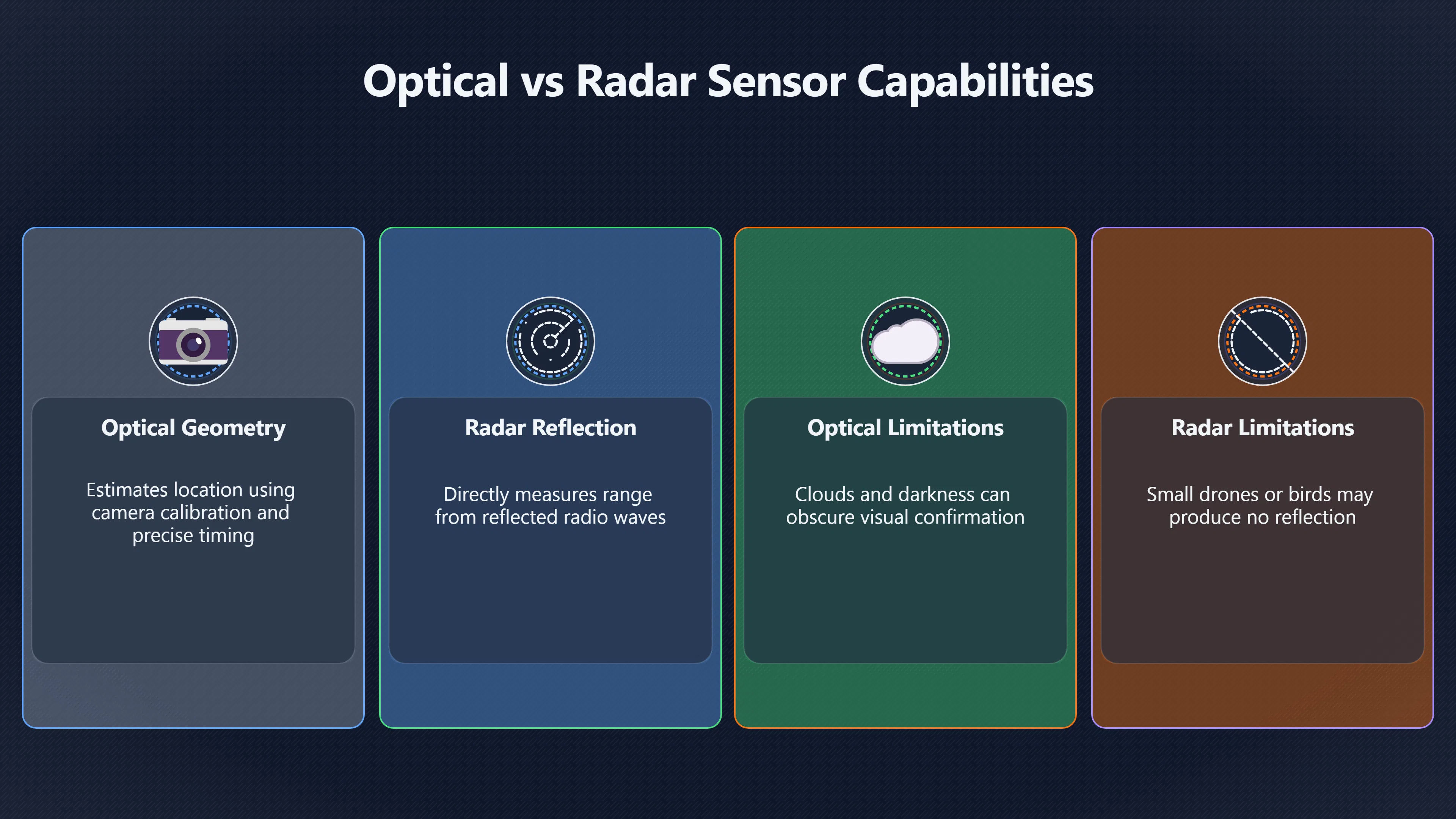
Optical range versus radar range
Optical and radar systems measure different physical quantities, making them complementary rather than interchangeable.
Optical triangulation estimates location from geometry. Its accuracy depends on camera calibration, precise timing and successful matching of the same object across different stations. Radar, by contrast, can directly estimate range from reflected radio waves while also measuring direction and, in many systems, radial velocity through Doppler processing. Agreement between independently derived optical and radar positions provides a much stronger test than either system alone.
Several outcomes are possible:
- Strong agreement: Optical and radar positions overlap within their stated uncertainties, increasing confidence that both sensors tracked the same object.
- Partial agreement: Both systems detect an object, but their estimated positions differ enough to suggest timing offsets, pointing errors or different targets.
- No radar return: This does not automatically imply an anomalous object. Small drones, birds, balloons, insects or distant lights may produce little or no detectable radar reflection depending on radar type, range and viewing geometry.
- Radar without optical confirmation: Clouds, darkness, limited camera field of view or poor optical sensitivity may explain why an optical system misses a genuine radar target.
For this reason, responsible analysis compares uncertainty estimates as well as the apparent track itself. A close visual overlap can still be statistically inconsistent once measurement errors are taken into account, while seemingly different tracks may agree within known sensor tolerances. NASA’s independent study highlighted calibration, metadata and multiple measurements as prerequisites for placing meaningful physical constraints on observed events. [NASA Science]science.nasa.govScience Independent Study Team ReportNASA ScienceIndependent Study Team ReportSeptember 13, 2023 — At present, analysis of UAP data is hampered by poor sensor calibration, th…
Using aircraft, weather and acoustic context
Most triangulated tracks are ultimately interpreted by comparing them against independent contextual databases rather than by analysing the images alone.
Aircraft identification through ADS-B
Automatic Dependent Surveillance–Broadcast (ADS-B) allows many aircraft to broadcast their GPS-derived position, altitude, velocity and identity. A reconstructed optical trajectory can therefore be compared with known aircraft movements in both space and time.
Modern observatory designs increasingly incorporate local ADS-B receivers directly into the sensor network. The Galileo Project has described using aircraft with known ADS-B positions to calibrate infrared camera orientation and to correlate detected tracks with known traffic before treating them as unidentified objects. This approach turns everyday aircraft into continuous calibration references rather than simply objects to exclude. [MDPI+2arXiv]mdpi.comThe rotation matrix and translation vector which convert a camera's coordinate frame to world…Read more…
ADS-B is not a complete catalogue of everything flying. Military aircraft, some light aircraft and certain operating conditions may reduce coverage, while non-cooperative objects such as birds or balloons obviously transmit no transponder data. Consequently, the absence of an ADS-B match does not automatically make a track anomalous. [MDPI]mdpi.comThe system…Read more…

Weather as an independent constraint
Meteorological information provides another valuable consistency check.
Wind profiles help determine whether a reconstructed path matches the expected motion of balloons or drifting debris. Cloud height measurements indicate whether an object should have been visible at all from a given station. Temperature inversions, atmospheric refraction and precipitation can also influence optical appearance and radar behaviour.
Comparing a triangulated trajectory against weather observations therefore helps distinguish genuine manoeuvres from passive motion driven by atmospheric conditions.
Acoustic measurements
Sound provides a fundamentally different measurement because it propagates far more slowly than light.
If microphones detect an aircraft engine or rotor signature, the arrival time of the sound should be consistent with both the object’s reconstructed position and the speed of sound under local atmospheric conditions. Conversely, an apparently low-altitude object producing no detectable sound is not necessarily anomalous: distance, wind, terrain shielding, ambient noise and the object’s own acoustic output all affect detectability.
Recent work on multi-band acoustic monitoring for instrumented UAP observatories emphasises that microphones are best viewed as an additional validation channel rather than a primary detection system. Aircraft recordings are also useful for training automatic classifiers that recognise familiar acoustic signatures. [arXiv]arxiv.orgarXiv Multi-Band Acoustic Monitoring of Aerial SignaturesMulti-Band Acoustic Monitoring of Aerial SignaturesMay 29, 2023…
Why corroboration matters more than one impressive clip
The strongest evidence is not the most visually dramatic recording but the event that survives repeated independent checks.
A bright light recorded by one camera can often support several competing explanations. Once multiple calibrated sensors are added, many possibilities disappear. For example:
- A triangulated position aligns with an ADS-B-equipped aircraft and matches its reported altitude and speed.
- A reconstructed path follows upper-level winds expected for a weather balloon.
- Radar and optical data agree on distance, but acoustic timing rules out a nearby low-altitude object.
- A visually striking track proves inconsistent with synchronised timestamps, revealing that different stations were tracking different targets.
These examples illustrate why modern instrumented observatories increasingly emphasise sensor fusion rather than relying on any single technology. The goal is not to accumulate more sensors for their own sake but to reduce ambiguity through independent tests that either reinforce or challenge the same reconstructed trajectory. Proposed UAP observatories now describe integrated processing pipelines that combine calibrated optical measurements with infrared imagery, ADS-B data, acoustic sensing and additional environmental instruments specifically to support this cross-validation process. [World Scientific+2arXiv]worldscientific.comWe are developing a multi-modal…

The governance value of multi-sensor verification
Multi-modal corroboration also improves the credibility of automated UAP detection programmes.
Standardised calibration procedures, synchronised timestamps, documented sensor characteristics and preserved metadata allow outside investigators to reproduce analyses instead of relying on subjective interpretation. That makes false positives easier to identify, enables performance auditing of detection algorithms and supports transparent reporting standards across different observing sites.
From a governance perspective, this shifts discussion away from debating individual videos towards evaluating measurable evidence. A triangulated track becomes scientifically useful not because it appears unusual, but because every available sensor has had an opportunity to confirm—or refute—the same physical path. That emphasis on reproducible, independently testable measurements is increasingly recognised as the foundation for credible automated UAP observation systems. [NASA Science+2galileo.hsites.harvard.edu]science.nasa.govScience Independent Study Team ReportNASA ScienceIndependent Study Team ReportSeptember 13, 2023 — At present, analysis of UAP data is hampered by poor sensor calibration, th…
Amazon book picks
Further Reading
Books and field guides related to What checks a triangulated UAP track?. Use these as the next step if you want deeper reading beyond the article.
Handbook of CCD astronomy
First published 2006. Subjects: Charge coupled devices, Technique, Astronomy.
Practical Astronomy with Your Calculator Or Spreadsheet
Relevant to coordinate validation.
eBay marketplace picks
Marketplace Samples
Example marketplace items related to this page. Use the search link to explore similar finds on eBay.

Endnotes
-
Source: science.nasa.gov
Title: Science Independent Study Team Report
Link: https://science.nasa.gov/wp-content/uploads/2023/09/uap-independent-study-team-final-report.pdfSource snippet
NASA ScienceIndependent Study Team ReportSeptember 13, 2023 — At present, analysis of UAP data is hampered by poor sensor calibration, th...
Published: September 13, 2023
-
Source: nasa.gov
Title: update nasa shares uap independent study report names director
Link: https://www.nasa.gov/news-release/update-nasa-shares-uap-independent-study-report-names-director/Source snippet
UPDATE: NASA Shares UAP Independent Study Report14 Sept 2023 — The report contains the external study team's findings and recommendations...
-
Source: galileo.hsites.harvard.edu
Link: https://galileo.hsites.harvard.edu/publications/scientific-investigation-unidentified-aerial-phenomena-uap-using-multimodalSource snippet
tware and instrumentation system designed to conduct a multimodal census of aerial...Read more...
-
Source: mdpi.com
Link: https://www.mdpi.com/1424-8220/25/3/783Source snippet
The rotation matrix and translation vector which convert a camera's coordinate frame to world...Read more...
-
Source: arxiv.org
Link: https://arxiv.org/abs/2411.07956Source snippet
Commissioning An All-Sky Infrared Camera Array for...by L Dominé · 2024 · Cited by 11 — The Galileo Project is designing, building, and...
-
Source: mdpi.com
Link: https://www.mdpi.com/2226-4310/4/3/49Source snippet
The system...Read more...
-
Source: arxiv.org
Title: arXiv Multi-Band Acoustic Monitoring of Aerial Signatures
Link: https://arxiv.org/abs/2305.18551Source snippet
Multi-Band Acoustic Monitoring of Aerial SignaturesMay 29, 2023...
Published: May 29, 2023
-
Source: arxiv.org
Title: arXiv Galileo Project Observatory Class System Architecture
Link: https://arxiv.org/abs/2506.00125 -
Source: arxiv.org
Link: https://arxiv.org/html/2506.00125v1Source snippet
1 Introduction30 May 2025 — A system designed for the comprehensive scientific study of aerial phenomena which integrates multiple sensor...
Published: May 2025
-
Source: space.com
Title: nasa ufo uap study team first results revealed
Link: https://www.space.com/nasa-ufo-uap-study-team-first-results-revealedSource snippet
NASA UFO report finds no evidence of 'extraterrestrial...14 Sept 2023 — "At present, analysis of UAP data is hampered by poor sensor cal...
-
Source: science.nasa.gov
Link: https://science.nasa.gov/uap/Source snippet
nasa.govUAP9 Jun 2022 — We commissioned a study team to examine from a scientific perspective unidentified anomalous phenomena (UAPs) – t...
-
Source: galileo.hsites.harvard.edu
Link: https://galileo.hsites.harvard.edu/searchSource snippet
The Galileo ProjectThe Galileo Project aims to shed light on the nature and characteristics of Unidentified Aerial Phenomena (UAP). We...
-
Source: ui.adsabs.harvard.edu
Link: https://ui.adsabs.harvard.edu/abs/2024AGUFMP11C..299D/abstractSource snippet
of an All-Sky Infrared Camera Array...by L Domine · 2024 — The Galileo Project is designing, building and commissioning multi-modal grou...
-
Source: astronomer.pro
Link: https://astronomer.pro/the-galileo-project-a-scientific-initiative-for-investigating-ufo-phenomena/ -
Source: mdpi.com
Link: https://www.mdpi.com/2072-4292/14/16Source snippet
Remote Sensing | August-2 2022 - Browse ArticlesThis paper examines the potential to derive bathymetries from video imagery under challen...
-
Source: worldscientific.com
Link: https://www.worldscientific.com/doi/full/10.1142/S2251171723400081?srsltid=AfmBOoqcKHAiLg9d4Swk37xNuDgupzvWEfCs7b09Yg06MWp5VdnjDR78Source snippet
We are developing a multi-modal...
-
Source: Wikipedia
Title: Automatic Dependent Surveillance–Broadcast
Link: https://en.wikipedia.org/wiki/Automatic_Dependent_Surveillance%E2%80%93BroadcastSource snippet
Automatic Dependent Surveillance–BroadcastADS-B is an aviation surveillance technology and form of electronic conspicuity in which an...
-
Source: caac.gov.cn
Link: https://www.caac.gov.cn/ZTZL/RDZT/XJSYY/201511/P020151126513090308243.pdfSource snippet
Multi-Sensor Tracking (MST) for ADS-B6 Jun 2012 — ADS-B equipment. ♢ Provide mapping from aircraft registered numbers and airline company...
Additional References
-
Source: researchgate.net
Link: https://www.researchgate.net/publication/388466760_Commissioning_an_All-Sky_Infrared_Camera_Array_for_Detection_of_Airborne_ObjectsSource snippet
(PDF) Commissioning an All-Sky Infrared Camera Array for...10 Jan 2025 — To address this deficiency, the Galileo Project is designing, b...
-
Source: researchgate.net
Link: https://www.researchgate.net/publication/404942120_PROPOSAL_Project_Dark-Track_Integration_of_Uncorrelated_Radar-Transponder_Telemetry_into_the_Galileo_Project_EXECUTIVE_SUMMARYSource snippet
Project "Dark-Track" Integration of Uncorrelated Radar-...18 May 2026 — The Galileo Project is doing incredible work to bring rigorous s...
Published: May 2026
-
Source: airservicesaustralia.com
Link: https://www.airservicesaustralia.com/wp-content/uploads/FAQ_ADS-B_DEC16.pdf -
Source: researchgate.net
Link: https://www.researchgate.net/publication/377871814_Exploring_Unidentified_Aerospace_Phenomena_through_Instrumented_Field_Studies_Historical_Insights_Current_Challenges_and_Future_DirectionsSource snippet
Historical Insights, Current Challenges, and Future DirectionsThe study of Unidentified Aerospace Phenomena (UAP) requires a shift from a...
-
Source: studocu.com
Link: https://www.studocu.com/en-us/document/harvard-medical-school/estadistica/nasa-uap-independent-study-team-final-report-key-findings-and-recommendations/157385671Source snippet
NASA UAP Independent Study Team Final ReportAt present, analysis of UAP data is hampered by poor sensor calibration, the. lack of multipl...
-
Source: avi-loeb.medium.com
Link: https://avi-loeb.medium.com/commissioning-data-on-half-a-million-objects-in-the-sky-from-the-galileo-project-observatory-are-a23bd084233aSource snippet
Data on Half a Million Objects in the Sky from...A collection of sensors in the Galileo Project Observatory at Harvard University monito...
-
Source: thedebrief.org
Link: https://thedebrief.org/galileo-project-releases-commissioning-data-on-half-a-million-aerial-objects-are-any-of-them-uap/Source snippet
Galileo Project Releases Commissioning Data on Half a...12 Nov 2024 — The Galileo Project radio sensor collected airplane positions from...
-
Source: rev.com
Title: unidentified anomalous phenomena independent study report from nasa transcript
Link: https://www.rev.com/transcripts/unidentified-anomalous-phenomena-independent-study-report-from-nasa-transcriptSource snippet
UAP Independent Study Report from NASA18 Sept 2023 — The Unidentified Anomalous Phenomena from NASA released a report to the public. Read...
-
Source: leonarddavid.com
Title: unidentified anomalous phenomena uap nasa independent study draws reaction
Link: https://www.leonarddavid.com/unidentified-anomalous-phenomena-uap-nasa-independent-study-draws-reaction/Source snippet
Unidentified Anomalous Phenomena (UAP) – NASA...15 Sept 2023 — NASA's Unidentified Anomalous Phenomena (UAP) Independent Study Team publ...
-
Source: metabunk.org
Title: avi loebs galileo project posts first results to near total silence.13795
Link: https://www.metabunk.org/threads/avi-loebs-galileo-project-posts-first-results-to-near-total-silence.13795/Source snippet
Avi Loeb's Galileo Project posts first results to near total...1 Dec 2024 — The paper is here: it's about building an all-sky infrared c...
Topic Tree